From: M Dawson
To: planning.enquiries@southtyneside.gov.uk
Subject: Slipway Development – River Drive.
Date: Fri, 10 Jan 2014 15:55:35
Dear Sir.
Please find attached copies of drawings nos. 8296/1A and 8296/1B, 8296/14 and a photograph of the road end elevation of the slipway development.
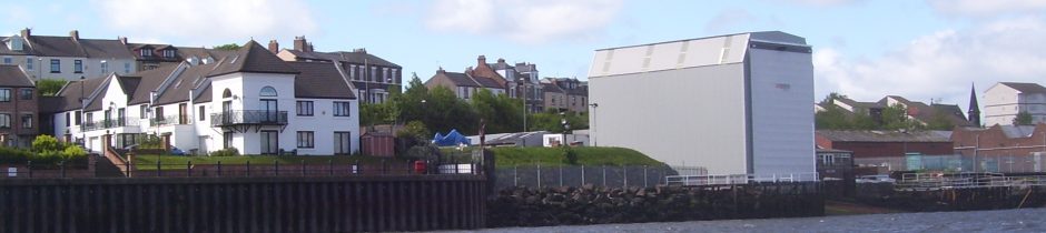
I notice that work on this site has recommenced in the last day or so and I am surprised as there is still an outstanding issue which I think has not been addressed. The issue relates to the second condition of planning permission granted under ST/0242/96/UD which has not been met. This condition states:- “The development to which this permission relates shall be carried out in complete accordance with the approved plans and specifications”. Plan drawing no 8296/1B received in the planning office on the 6th Sept was circulated to concerned residents. However it was noted the plan did not represent the structure erected on River drive. Comparison with the photo labelled Slipway Cover shows this quite clearly, the existing pillars are vertical while the drawing shows a sloped construction.
Taken befor the fifth frame was erected. Note the additional space at roof height and the additional lugs for fitting the overhead crane!
The structure is 15.5m high on the south elevation therefore some18.5m high at the north, the river end. I have estimated that that the width of structure is 13.2m the drawings detail 12.2.
Plan drawing no 8296/1A was sent to me after I requested the approved and date stamped plan. This drawing is a precursor to 8296/1B and still does not represent the structure on River drive. However it is dated and stamped ‘South Tyneside MBC 11 April 1996’ when residents have been advised the Council had no involvement.
There are no detailed plan drawings available to the public for ST/0242/96/UD. There is only one drawing for ST/1146/13/COND, which shows the river facing elevation and details of the strip curtain door fixings. Examination of this drawing number (8296/14) gives a detail of a beam (portal column) width 0.686mtres, with which the height and width of the north elevation can be gauged. The north elevation is 15.6m high with a width of 12.2m. When looking at the three drawings and the photo I have forwarded, it is obvious that there is a complete miss match. It is therefore reasonable to conclude that the current structure has not been built to the ‘approved plans’ as provided by Council, ie 1A,1B nor does the drawing of the cladding/door fixing detail match what exists, for example the structure is 3 metres higher and 1 metre wider than shown on 8296/14.
Please will you answer the following questions:
Why are there no date stamped and approved plans available on the planning portal?
Why are there no plans for the current structure?
As the applicant has not discharged condition 2 why is there no retrospective planning application?
Why when I have been provided with a drawing dated 1996 were residents informed Council was not involved at this time?
I am now again requesting copies of the plans date stamped and approved in 1996 and any approved revisions to these plans.
yours sincerely
Mr M Dawson
Attachments:-
- D8296_1A.pdf
- Longitudinal Section &
D8296_1B.pdf - D8296/14.pdf – see reference
- Photograph from Greens Place
This observation that the enclosure was not built to plan and the Council have not issued an enforcement notice still remains unanswered.