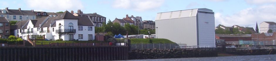
When we were trying and failing to get information about the planned height of UK Dock’s slipway cover out of the Council, a few of us suggested that we get the Tyne Gateway Assn (TGA) involved and an AGM was convened because it had gone dormant. The main item on the agenda was the suspected breach of planning control with regard to the height and width of the cover.
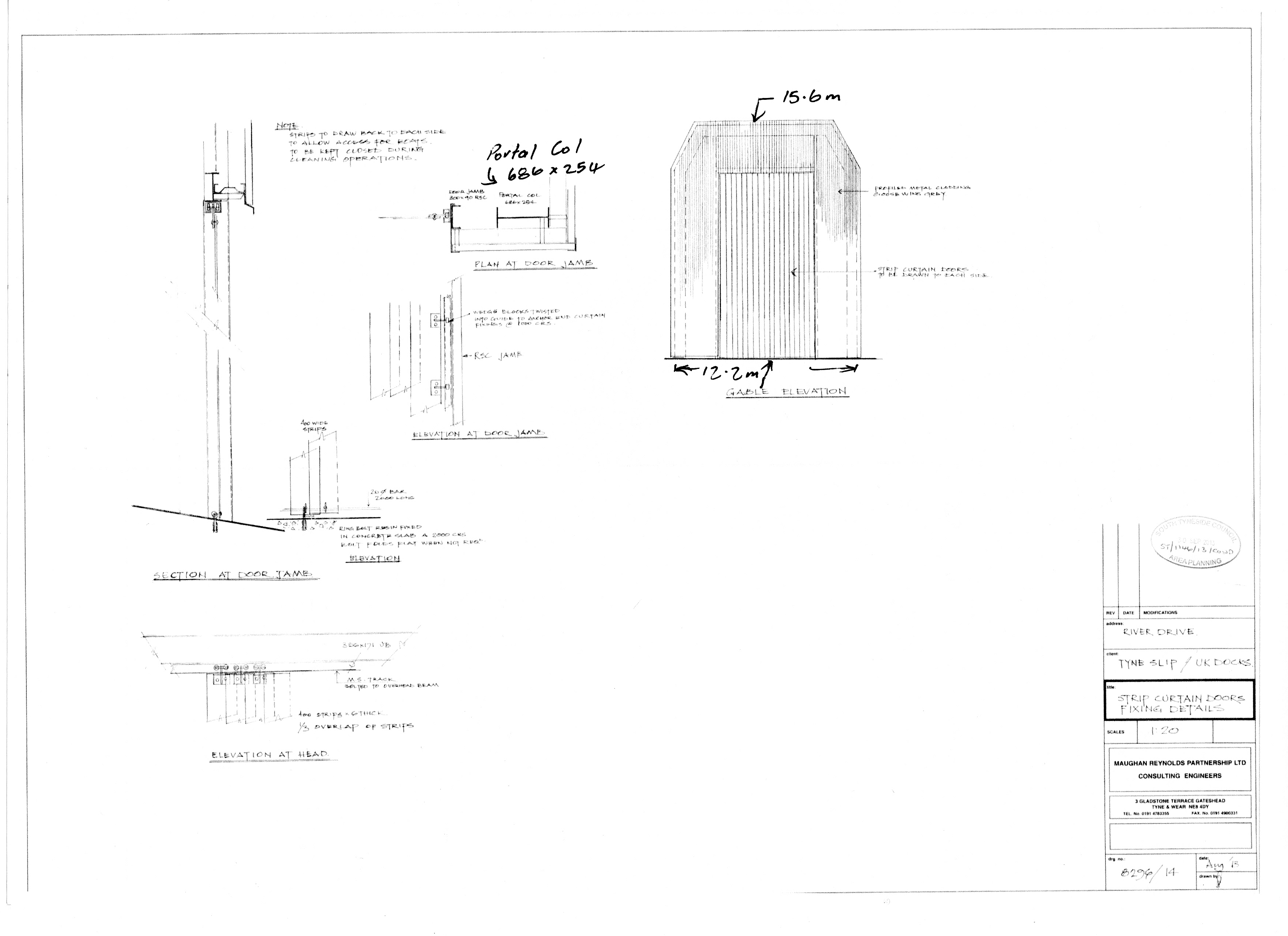
The minutes are not clear but the dimensions are from the first drawing and the further drawing was amendment from February 1997 and therefore could not have been stamped in 1996. It also shows both ends of the cover or enclosure to be 15.5m high so it can be interpreted in two ways.*
I thought that the Chairman would stand down because of his business interests, being a procurement officer for HB Hydraulics but he did not and to compound things one of it’s directors, became Treasurer. Thus control of the TGA passed from the Residents to a business dependent on the goodwill of the shipyards on the Tyne.
‘HB Hydraulics‘ site gives nothing away but they had an office in Wallsend on Tyneside at the time the development of the slipway started. The closure of the slipway at Tyne Dock would leave A&P Group and UK Docks as the last two ship repair yards on the Tyne.
Cllr Anglin also volunteered at the same AGM to get evidence one way or the other and the height business resolved as there was some discussion about which end of the shed was supposed to be 15.5 tall. Notice the term ‘legal’ has replaced breach of planning control.
Some of us did not trust him and asked to attend any meeting he arranged. As I was to attended the meeting I was asked to request the Council for evidence that the cover had been built to approved plans but none was produced.
At meeting with the Principal Planning Officer at the Town Hall, November 2013, we were told the cover was neither too high nor too wide. I doubted what he was saying because he did not willingly provide any drawings to back his view and the drawings he sent later were not authorised and contained mistakes.
No evidence was provided to support the Council’ view nor at any time since. We were back to were we were in mid September: the Residents believing that the cover was oversize and the Council saying it was not:
Mr Dawson – once again – I have measured this on site and have copied the 1996 plans across to you twice already (attached again for your use) and I have explained during our meeting that the base and height of the structure are compliant…this is the end of the matter as far as I am concerned
Please do not email me again
Regards
Peter Cunningham
Principal Planning Officer.
Two events took place between the meeting and the receipt of this email:
- The width of the cover was measured from Greens Place by sighting along the columns and found to be a meter wider than planned and Cllr Anglin and the other attendees were advised.
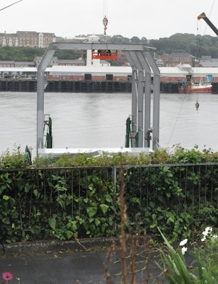 This was easy to do by sighting along the frames and putting chalk marks on the handy railings. A plumb-line helps with the accuracy and a little bit of maths is required because the railing are not square onto the frames nor straight. The pillars have been made vertical which was not in the original plan but it allowed us to determine that the footings for them which were laid in 2001. Laid to meet the first condition they breached the second.
 - The Agent’s drawing was part of a Decision approved by the Council in October 2013 appeared on the Planning Portal. This showed that the river end of the UK Docks drawing was 15.5m high rather than the landward end. The cover is therefore nearly 3m taller than planned.*
I wrote to Cllr Anglin (and the other attendees) that we had been misinformed at the meeting but he did not reply but the Planning Officer and the Chair of the TGA did:
- Mr Peter Cunningham: Mr Dawson – when did you get access to measure the structure on site ?
- Chair of TGA: In my opinion the only way to get these measurements with the accuracy stated would be to gain access to the boatyard and physically measure between the various points on the footings.
At the last meeting of the TGA I did offer to explain how I had measured the width but he declined my invitation and both the Principal Planning Officer and his Manager went on to say that there was no breach in planning control.
The fallout from the meeting poses 3 questions:
- why was the Principal Planning Officer telling us that the cover was not too high when the approved drawings showed otherwise *;
- why was the breach in the planned width not reported when the footings were laid in 2001;
- where did the Councillor stand in all this? He allowed the Council to use a meeting which he arranged to silence a valid protest about a serious beach of building control.
* There is an authorised drawing from 1996, 8296/2, which gives the landward end a height of 12.7m which was recovered by the Council from their archive in September 2013.
The river end of cover is also shown as 15.5m on 8296/1A and 1B which gives the landward end a height of 15.5m less the gradient or 12.8m.
** apparently [PROTECT] is for internal use by the Council but its use coincides with the emails which contain misinformation.