Again for each entry, #no is the relevant paragraph, or part of, from the Final Draft of the Ombudsman’s findings 15-Apr-15. The first part of it is what the Inspector was told by me and the second is what she said in her findings. The summary is at the end.
| We said | she said about the height. | ||
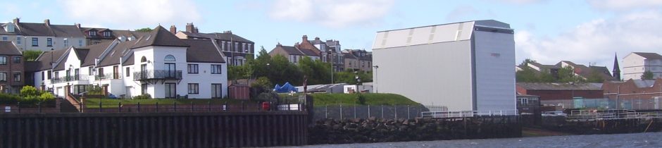
| #30 | 1)Thank you for the copy of your draft decision and the covering letter. The first thing I notice is that there is no mention of the height of the shed. I maintain that as well as being built 1m wider than planned, the shed is also 3m higher. 2)“Detail of river end (north) elevation: Height of shed at river end is 15m (12.5+3m)” from explanation of 8296/1A (15.5-2.7m = 12.8m). |
|
| She said: | 3) Mr X says the shed is also 3 metres higher than shown in the 1996 plans. He says a scale measurement from the plans shows a total height of 12.75 metres at one end of the shed. | |
| What follows is mostly misinformation provided by the Senior Planning Officer. | ||
| #31 | 1) I have shown that he is using an error on the drawing (8296/1A) to justify his flouting of Condition 2. It speaks of incompetence or worse for a senior planning officer to have overlooked this. 2) Correction – the Planning Manager said that the shed was built not built to an approved plan |
|
| She said: | I have discussed this with a senior planning officer. The Council accepts that using a scale measurement against the 1996 drawings would not give a measurement of 15.5 metres. It says this plan has several drawings using different scales and some are foreshortened; possibly to fit on the paper. It says these are likely to be engineer’s drawings. It says what it relied on was the dimensions written on the plans by the applicant. The applicant stated the height at this end as 12.5 metres plus 3 metres making 15.5 metres. The Council says the permitted height at this end is 15.5 metres and this is the height as built. The detail, which is an error is from a drawing that has been stretched rather than foreshortened. * | |
| #32 |
1) I have shown that he is using an error on the drawing (8296/1A) to justify his flouting of Condition 2.
|
|
| She said: | It is too long ago for the Ombudsman to consider a complaint about the accuracy of the drawings accepted by the Development Corporation in 1996. In any event the applicant had written the dimensions and this is what the Council considered rather than measuring and scaling the drawings. The error will remain until corrected – probably why the drawing was not approved. | |
| #33 |
The gable end is the one facing the river. In case there is any confusion:- Detail notes on the drawing ” strips to draw back to each side to allow access for boats” The boats come up the slipway from the river.
|
|
| She said: | In response to a draft of my decision Mr X says the 15.5 metres height relates to the river end. He considers the land end should be 2.6 metres lower. He says the Council cannot prove 15.5 metres relates to the land end not the river end. I do not agree. | |
| #34 | 8296/1B sent by the Senior Planner to the LGO. It does not represent the approved development being an amended drawing from Feb’ 97. Even Customer Advocacy agree with me on this point (Stage III, top of page 2, 25-Sep-14) where you can see it is missing from the list. 8296/1A is still on the list because it appears that they agree with our view (and I am writing on behalf of all the 300 petitioners) that the shed is 2.7m too high. 1A can be interpreted in two ways and it was probably fraudulent to use it in the way it was presented to the Inspector. | |
| She said: | I have seen the 1996 plans. On plan 1/B the applicant has written the proposed elevations at the inland end as 12.5 metres plus 3 metres. Mr X says the Council should not have taken the applicant’s word for this. The planning authority has to consider what an applicant applies for; it can grant or refuse this but it cannot make an applicant submit something different. This developer applied for a shed 15.5 metres high at the land end. The Tyne and Wear Development Corporation as planning authority approved this. The current Council had to accept this as the approved height. | |
| #35 | She was told in my explanation that the height of shed at river end was 15m (12.5+3m) and therefore the road end must be some 3m lower. I also said the Planning Office have put forward an explanation to try and justify a road end height of 15.5m and account for the fall of 3m by making the planned height of the river end 18.2m. This cannot be supported if one looks carefully at the drawing. Explanation of Drawing 8296/1A, 6-Apr-15 | |
| She said: | In January 2014 the Council wrote to Mr X about this. It said the overall structure on the plans is 15.5 metres at the land end and the foundations are 2.656 metres lower at the river end due to the gradient. It said the agreed structure is much higher at the river end. It said it had taken measurements on site and the shed as built matches these measurements. Since then the Council has consistently told Mr X the shed is the correct height. The measurements may match the road end measurements but I have shown her that they are wrong and that the Planning Manager is using an error to misrepresent the plans. Repeating a lie does not make it true – 8296/1A also shows the riverside end to be 15.5m above foundation level as well! It is best to look at an approved drawing to determine whether the Planning Manager was lying or not. | |
| #36 | The report written for the planning committee by officers of the Development Corporation in 1996 appears to have been sent by the Council to confuse matters. It is not specific about which end has a planned height of 15.5m but it is very specific about things like Sunday working and the desire of the Council to see that no further expansion of the boat yard takes place. | |
| She said: | I have seen the report written for the planning committee by officers of the Development Corporation in 1996. The report says the height is 15.5 metres. Mr X says it does not specify which end is 15.5 metres. The report says “the design, height and location of the proposed shelter can be seen in the display material which will be presented at the meeting”. From this it is clear the Development Corporation knew the proposed height was 15.5 metres at the inland end and gave permission for this. Wrong again see – #35. | |
| #37 | The original complaint 10-Jan-14 said:“Examination of this drawing number (8296/14) gives a detail of a beam (portal column) width 0.686mtres, with which the height and width of the north elevation can be gauged. The north elevation is 15.6m high with a width of 12.2m.” The drawing shows the river gable end. The drafter has said which end of the shed it is and it is drawn to a scale of 1:100 and is 16cm high on the drawing presented to the Council in September 2013. | |
| She said: | Mr X says plan 14 shows 15.5 metres as the river end height. The Council has explained to Mr X why this is not the case… One drawing shows an end with the panels in place to provide an impression of the final appearance. The drafter has not specified which end this is and the drawings are not to scale. |
|
| #38 | As one can see the Council has been consistent in promoting the misrepresentation made by the Planning Manager in January 2014 and downplaying the significance of the approved document 8296/14. | |
| She said: | The Council has provided a consistent and sound justification for its view the shed as built is the same height as that granted permission. The Ombudsman cannot criticise the Council’s view.
Consistent maybe – sound, not at all. |
|
Ombudsman’s Summary: This complaint is not upheld. In 2013 a developer resumed building a boat shed for which he had planning permission and had started building in 2001. 1 Local residents complained but the Council found the developer could still build the shed. However, he had built it almost a metre wider than he should have done. 2 There is no evidence of fault in the way the Council dealt with the breach of planning control and its decision not to take enforcement action. 3 It kept residents informed 4 throughout the process.Note.
|
||