I understand that on completion there is to be the opening on each of the gable ends. Not an opening to let boats in. There is just door on the landward side to let the men and bits of equipment in and out of the shed from the rest of the site.
Not drawn to scale
The practice of drawing details without scale is frowned upon in standard drawing practice and there is no excuse for it with modern CAD and where there is plenty of space on the page.
There is no mention of the gable elevation not being to scale when he wrongly said it was the road end in the email of Jan 28 – to quote: “In fact the 15.6m height is the height to River Drive and the height on the river side is some 3m greater.“
Why did we determine the elevation on 8296/14 is the south end?
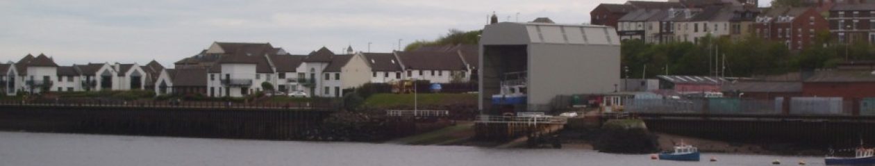
This question can only answered truthfully by saying “because we were wrong”. It is not the south or road end, it is the river end because it has a door to let the boats in.
Requirement to improve the structural stability of the shelter by taking the steelwork to ground level has resulted in it being constructed to a width of 13.1m when measured at ground level.
As said elsewhere the footings for the columns were laid in 2001 and that they were laid nearly a meter wider than planned. If the extra width was a requirement to improve the structural stability then this would appear to be dictated by the extra height of the shelter and making the pillars vertical (3m) rather than anything else. The point he makes about it being wider implies that plans were being made in 2001 to make it wider and taller. Who signed off the work done in 2001?
That the extra width and making the side vertical allows the crane to fit nicely into the framework is surely more than a coincidence.
In fact the 15.6m height is the height to River Drive and the height on the river side is some 3m greater.
To put it plainly – he is wrong. In this context we are referring to drawing 8296/14 and there are three pointers to indicate that the drawing is of the river end elevation. I have to write again to point this out to him.
And you seem to have assumed that is the riverside elevation.
It is obvious that the elevation is the riverside end of the shelter. There are three pieces of evidence that show the elevation is riverside elevation; it is not an assumption:
Detail note on the drawing, “strips to draw back to each side to allow access for
boats”;
The section at the door jam shows the cladding on the downward ie. North/river
end. The alternative would have the cladding on the inside of the building;
The apparent use of third angle projection would imply that the door is at the north end.
Dimensions of the shelter are as measured by the Council in September: Length 22.254m; Width 13.1m;Height at end facing River Drive 15.5m
All the plans show a planned width of 12.2m for the shelter so it is built nearly a meter wider than planned. This not what STC have been saying for the previous four months.
Following a search of our archived file the only drawings that we have that are stamped ‘Approved by Tyne and Wear Development Corporation’ are 8296/2 and 8296/4.
These have been available to view since Sept 11th 2013. Although the staff at the town hall have allowed inspection of the discs it is very difficult and copies have not been allowed, see disc viewing by Paul, Nov 2013. These are the first issued to anyone outside of planning.
8296/2 is a scale drawing and tends to support the argument that the shelter is 3m too high. Using the gradient (2.656m drop along the length) the road end and river end work out to be 13m and 16m respectively. Review III.
8296/4 is an illustration of the translucent panels and is not to scale.
the company provided from its own sources copies of drawings numbered 8296/1B and 8296/2
Neither of these two drawings show authorisation details, 8296/1B is drawn six or seven months after the grant of permission and 8296/2 is truncated and shows no number nor height details. From the length of the shelter on the site elevation (page 1 of pdf file) one can estimate that the heights are 13.5 and 16.5m.