Amended Planning Application – ST/0461/14/FUL.
From: Michael Dawson of: Amble, Morpeth
Dear Garry,
I am writing to you directly because I wish to draw your attention to two problems with the way your office is handling this application.
First: Mr Mansbridge says at the beginning of his letter about this proposal, “I refer to my previous letter in which I offered you the opportunity to give your views on the above application”. I have not had a previous letter from him and not aware that anyone else has either.
When Mr Atkinson sent out the letter about this application last year there was information about availability of representations, material planning considerations, who makes the planning decision and speaking at Planning Committee. There is no mention of these in Mr Mansbridge letter, 10 Sept 2015. It would appear that Mr Mansbridge has either decided not to delegate this application to Committee or, if I read the last line of his letter correctly, all our representations from last year will be discarded if we do not reply to this letter.
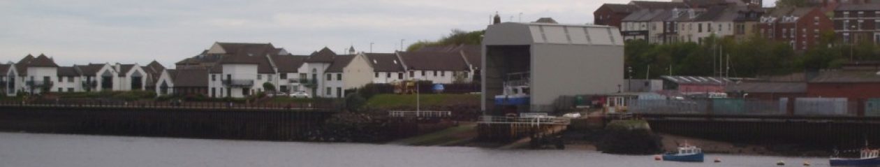
Second: The first shed has been built without planning permission, admission by Customer Advocates, November 2014, but Mr Mansbridge has decided that he need take no action against UK Docks. The shed is, as everybody now agrees, a meter wider than planned although I would like to point out that your office (emails from both your Principal Planning Officer and your Planning Manager) maintained it was built to authorised plans for the first four months of its existence.
The first shed is also 3 meters taller than the plans held by your office allow and the planning application ST/0461/14/FUL shows that UK Docks wish to extend it by by 25% – drawing No 9 of the application. You appear to be accepting an application to extend a structure that does not have planning permission.
Mr Mansbridge says that the shed is not 3 meters taller than planned in spite of evidence to the contrary, indeed he wrote to residents in May last year:- “Apart from the width these dimensions are either entirely in accordance with the approved plan, or subject to such minor deviation that they are properly categorised as non-material changes”.
Drawing 8296/1A is the one preferred by Mr Mansbridge when he says that the height of the shed is not materially different from that planned. He used this drawing (there is no other available unless you count 8296/1B and he cannot use 8296/14 for he claims wrongly that it is not to scale) when wrote to residents in the same letter to say that although the shed was built without planning permission he was taking no action. He said that the drawing to say that the steelwork at the road end is clearly marked as 15.5m. It is significant that he does not attach the drawing to his letter because the river end is also clearly marked as 15.5m.
The gradient is 2.656m (there is no dispute about that) and both ends cannot be 15.5 meters. Even an untrained eye can see that the dimensions on the road end have been carelessly done. The 12.5m should be pointing to the top and not to the hip of of the ‘mansard’. I suggest you look again at 8296/1A and I think that you cannot but agree with me that whoever advised Mr Mansbridge was not telling him the whole story.
Drawing 8296/1A was not authorised by T&WDC and I believe it was because of the misleading dimensions but they did authorise drawing 8296/2. If the gradient (2.656m) is used to give it a scale the dimensions of the elevation are:- 13m road end, 16m river end and length 22m. This gives much weight to the contention that the shed has been built 3m too high.
I referred to drawing 8296/14, the drawing on the planning portal, above, as it is the one that I used to gain the admission from your Planning Manager that the first shed was not built to authorised plans. It is only a detail but has sufficient information on it to work out that the the river gable end has a height of 15.6m and a width of 12.2m. When your Planning Manager wrongly said it was the road end in an email in January, he said nothing about scale. It was only when he could no longer maintain the myth about which end the drawing applied to, did he say that it was not to scale. Please examine the drawing 8296/14 yourself and tell me that a) it is not to scale, b ) the height is not about 15.5m (rather than 18.5m) and c) the elevation is not the river end. This drawing shows that taking the gradient into account the planned height of the road end elevation should be about 12.5m, not 15.5m as built.
I think I have demonstrated that the current slipway shed is built built 3m higher than any plans provided by South Tyneside. It does not appear to be good planning practice to consider an application to extend a structure when it has been built without planning permission. I now turn to the matter in hand; the Amendment to planning application ST/0461/14/FUL. In case my suspicions aired in the first problem are correct I repeat my representations of last year:-
My understanding is that in 1996 as part of their approval for the current development, Tyne and Wear Development Corporation wrote to the proprietor of UK Docks stating that they would not support further expansion of this site so close to a residential estate. The River Drive development and its further planned development (Office block and additional slipway and shed) goes against the Local Development Framework. To quote “Capitalising on South Tyneside’s environmental assets is about taking measures to:
. Protect and enhance the strategic Green Belt, coastal and wildlife corridors;
. Ensure that development throughout the Borough reflects the character and distinctiveness of its surroundings;
. Boost the town centres of South Shields and Jarrow by linking them to adjacent World Heritage Sites;
. Revive major riverside sites by reducing noise, pollution and risk; etc. Noise – Since the first slipway shed was erected noise emission has substantially increased for local residents. Some of this noise may have been the result of construction but machinery noise such as compressors etc will increase with further development. Machinery noise was never noticeable from my residence in Greens Place (120m west) until this year. Allegedly the applicants record in is unfavourable in other yards owned by UK Docks. STC no doubt have records of this fact.
Visual Amenity – The current Slipway construction on River Drive has resulted in a loss of Visual Amenity. Further development will obviously compound the loss. Visual Amenity can be defined as ‘a measure of the visual quality of a site or area experienced by residents, workers or visitors. It is the collective impact of the visual components which make a site or an area pleasant to be in. It is a consideration of elements which contribute to the visual pleasantness and character of towns, localities and neighbourhoods’.I consider that visual amenity of this area is reduced even further by the addition of the future development of this site.
Yours sincerely
Michael Dawson