It was assumed that Tyne Slipway & Engineering (now UK Docks) had planning permission for the shelter as the frames were very quickly assembled and erected.
The shelter appeared to be wider and taller than the plans allowed and this was mentioned in correspondence to planning in September 2013 – shown below. It should be noted that, though the size and location of the cover were questioned within a few days of the frames being erected, the Council appeared to take no action to test the validity of the plans supplied by the UK Docks or their agents.
It took another email to Planning enquiries (see 3 below) in January and a bit of persistence to get the Planning Office of South Tyneside Council to admit that it was not built as authorised. This was five months after the development started. It should be noted that work still continued on the shelter.
These emails, and more particularly the responses from Council are dealt with in some detail in ‘Evasion’.
The Planning Manager in his admission, that the shelter was not built to approved plans, did it in such a way as to allow misinterpretation in respect of the height of the shelter and this was used by the Head of Development Services, or allow others in STC to misinform people about the status of the shelter. This includes the local paper, residents in a letter of May 2nd 2014 and the Local Government Ombudsman in 2015.
Plans for lengthening the existing cover and building another longer one, submitted shortly after the cover was signed off were accepted by the Council and delegated straight away to committee. This was presumably because of the protests about the size and location of the cover already built.
M Dawson
26 June 15
Planning enquiries – 9th and 18th September 2013
1) Approved boat repair shelter at Tyne Slipway, River Drive, South Shields
From: Householder Greens Place
Date: Mon, 9 Sep 2013 15:20:49 +0100
CC: 5 Neighbours; cllr.john.anglin@southtyneside.gov.uk; cllr.audrey.mcmillan@southtyneside.gov.uk; cllr.john.wood@southtyneside.gov.uk
To: Peter.Cunningham@southtyneside.gov.uk
Subject: Re: Approved boat repair shelter at Tyne Slipway, River Drive, South Shields
Dear Peter,
From the stamp date on the revised plans, you have received plans on the 06.09.13 the day after construction commenced which show a increased height to the structure to that which was originally approved in 1996. Has the revised height of 15.5metres been approved or is it in breach of the 1996 Planning approval?
Please can you send me full details of the relevant complaints procedure.
Regards,
Householder
2) Tyne Slipway & Eng Co Ltd Erection of a Shelter ST/0242 /96//UD
From: Mick Dawson
To: planning.enquiries@southtyneside.gov.uk
Subject: Tyne Slipway & Eng Co Ltd Erection of a Shelter ST/0242 /96//UD
Sent: 18 September 2013 7:08:11
Complaint about the expansion of industry in a primarily residential area of South Shields. Main concerns:-
1) Noise. The erection of the shed can be easily heard for hundreds of yards along Greens
Place. Shipbuilding and repair is a particularly noisy trade so there is no reason to expect it to be any quieter than the erection of the shed. The disturbance of the fans on the roof of Prestige Seating Technologies nearby is a good example. These start up at any time after about 06:00 and run continuously during the day. The noise from a ship yard is not a continuous background hum and will be much more of a nuisance.
2) Deliveries and Access. There will also be continual trouble with deliveries and access which often take place during antisocial hours.
3) The height and ugliness of the new building. This appears to go against the long term plans for the riverside downstream of the Customs House to the coast. These always seem to show rather pleasing views of people strolling in pleasant riverside gardens.
Mr M Dawson
Greens Place
NE33 2AQ
While the height is mentioned, I have not said that the shelter was too tall as I had no way of confirming that it was oversize[0]. It did not dawn on me that the width could be measured quite accurately until a couple of months later. I claimed an accuracy of a couple of inches (5cm) but had not allowed for the misalignment of the frames that arose from construction coupled with the distance of observation.
Planning enquiry – 10th January 2014
3) Slipway Development – River Drive.
From: M Dawson
To: planning.enquiries@southtyneside.gov.uk
Subject: Slipway Development – River Drive.
Date: Fri, 10 Jan 2014 15:55:35
Dear Sir.
Please find attached copies of drawings nos. 8296/1A and 8296/1B, 8296/14 and a photograph of the road end elevation of the slipway development.
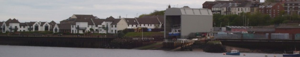
I notice that work on this site has recommenced in the last day or so and I am surprised as there is still an outstanding issue which I think has not been addressed[1]. The issue relates to the second condition of planning permission granted under ST/0242/96/UD which has not been met. This condition states:- “The development to which this permission relates shall be carried out in complete accordance with the approved plans and specifications”[2].
Plan drawing no 0296/1B received in the planning office on the 6th Sept was circulated to concerned residents. However it was noted the plan did not represent the structure erected on River drive. Comparison with the photo labelled Slipway Cover shows this quite clearly, the existing pillars are vertical while the drawing shows a sloped construction. The structure is 15.5m high on the south elevation therefore some18.5m high at the north, the river end. I have estimated that that the width of structure is 13.2m the drawings detail 12.2[3].
Plan drawing no 8296/1A was sent to me after I requested the approved and date stamped plan. This drawing is a precursor to 8296/1B and still does not represent the structure on River drive. However it is dated and stamped ‘South Tyneside MBC 11 April 1996’ when residents have been advised the Council had no involvement.
There are no detailed plan drawings available to the public for ST/0242/96/UD. There is only one drawing for ST/1146/13/COND, which shows the river facing elevation and details of the strip curtain door fixings. Examination of this drawing number (8296/14) gives a detail of a beam (portal column) width 0.686mtres, with which the height and width of the north elevation can be gauged. The north elevation is 15.6m high with a width of 12.2m[4].
When looking at the three drawings and the photo I have forwarded, it is obvious that there is a complete miss match. It is therefore reasonable to conclude that the current structure has not been built to the ‘approved plans’ as provided by Council, ie 1A,1B nor does the drawing of the cladding/door fixing detail match what exists, for example the structure is 3 metres higher and 1 metre wider than shown on 8296/14.
Please will you answer the following questions:
Why are there no date stamped and approved plans available on the planning portal?
Why are there no plans for the current structure?
As the applicant has not discharged condition 2 why is there no retrospective planning application?
Why when I have been provided with a drawing dated 1996 were residents informed Council was not involved at this time?
I am now again requesting copies of the plans date stamped and approved in 1996 and any approved revisions to these plans.
yours sincerely
Mr M Dawson
The immediate responses are on page 2.