21. The Council considered if the building accorded with the approved plans. The planning officer originally assigned the case considered the developers were building the boat shed to the measurements in the 1996 plans. Mr X says he told residents this at a public meeting. The Council accepts these measurements were wrong.
I repeated what the planning officer told me at a meeting in the Town Hall on 25th Nov 2013 to a meeting of Local Residents some 6 hours later. I did not believe what I had been told but I did not know the dimensions of the structure so I had to assume that what was being said was true. The dimensions were known to the Council in September but I was not given them until the end of January.
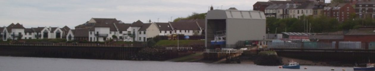
22. A more senior officer checked the measurements; he found the width at ground level was just less than one metre wider than the permission allowed. The Council decided the developer had not built the shed entirely in accordance with the approved plans and so had not met condition 2. The Council decided this was a breach of planning control.
Not what the Principal Planning Manager was saying on 13th January – that the base and height were compliant. Nor what the Planing Manager was implying two weeks later when he ascribed the drawing to the road end of the shed. I was eventually told what the dimensions were in an email, 28th January 2014, when I appealed to the his manager.
23 – The Council considered the difference between the permitted width and the width of he built shed and decided not to enforce. Enforcement is discretionary and the Council explained to residents in great detail how it reached its decision. It explained the law and policy it considered. There is no need for me to repeat this.
It decided the degree of departure from the plans – less than one metre – was “non-material.” Given the overall scale of the building, its decision is sound. The
Council took the view “comparing the as built development from that for which
permission was granted, there are not considered to be any additional significant
impacts to residential amenity that would justify taking enforcement action.” In
other words, there was not enough harm.
“– less than one metre –”. One cannot dispute that 0.2 is less than a meter, Mr Mansbridge in a letter to residents 2nd May, but the departure is 0.9m which is significant.
30 – Mr X says the shed is also 3 metres higher than shown in the 1996 plans. He says a scale measurement from the plans shows a total height of 12.75 metres at one end of the shed.
This is the first mention of the height in her findings when I examined the plans it was clear that the draughtsman has made a mistake in the dimensions of the road end of the shed in drawing 8296/1B.
He has repeated the dimensions from the river end; they should be 2.67m less.
31 – I have discussed this with a senior planning officer. The Council accepts that using a scale measurement against the 1996 drawings would not give a measurement of 15.5 metres. It says this plan has several drawings using different scales and some are foreshortened; possibly to fit on the paper. It says these are likely to be engineer’s drawings. It says what it relied on was the dimensions written on the plans by the applicant. The applicant stated the height at this end as 12.5 metres plus 3 metres making 15.5 metres. The Council says the permitted height at this end is 15.5 metres and this is the height as built.
Engineers drawings would by necessity be to scale. That she says ”dimensions written on the plans by the applicant” implies that the Senior Panning Officer is no longer referring to either 8296/1A nor 1B but the reference to 12.5 plus 3 means she is referring to 8296/1A or 1B.
Both of which state the river end has a height of 15.5m as well as the road end.
32 – It is too long ago for the Ombudsman to consider a complaint about the accuracy of the drawings accepted by the Development Corporation in 1996. In any event the applicant had written the dimensions and this is what the Council considered rather than measuring and scaling the drawings.
The Senior Planning Officer again!
33 – In response to a draft of my decision Mr X says the 15.5 metres height relates to the river end. He considers the land end should be 2.6 metres lower. He says the Council cannot prove 15.5 metres relates to the land end not the river end. I do not agree.
What I actually say on the 3rd February is:
With reference to the drawing 8296/14 I have made no assumptions regarding this drawing but have taken my information from the drawing. There are three indicators that the elevation is the north end of the structure:
1. Detail notes on the drawing ” strips to draw back to each side to allow access for boats”
2. The section at the door jam shows the cladding on the downward ie.North/river end. The alternative would have the cladding on the inside of the building.
3. The apparent use of third angle projection would imply that the door is at the north end. The north elevation height is therefore 15.5m and subsequently the south elevation 12.5m. What made you determine that the elevation is the South end when there is no such detail on the drawing? The north end is the river end and he does not answer the question.
34. I have seen the 1996 plans. On plan 1/B the applicant has written the proposed elevations at the inland end as 12.5 metres plus 3 metres. Mr X says the Council should not have taken the applicant’s word for this.
This drawing 8296/1B was, not authorised, produced in 1997 and says the other end of the shed is 12.5+3m as well.
Please note that I did not send 1/B to the Inspector.
35. In January 2014 the Council wrote to Mr X about this. It said the overall structure on the plans is 15.5 metres at the land end and the foundations are 2.656 metres lower at the river end due to the gradient. It said the agreed structure is much higher at the river end. It said it had taken measurements on site and the shed as built matches these measurements. Since then the Council has consistently told Mr X the shed is the correct height.
She is quoting from email from the Planning Manager 15 Jan 2014. “The drawing that was submitted on 11th April 1996 with the application is numbered 8296/1A. That shows the overall height of the structure as 15.5m above the foundation level at the landward end. At the riverside end the foundations are shown as 2.656m lower due to the gradient of the slipway. The structure would therefore be that much higher at the riverside end. 8296/1B is the same drawing captioned ‘Foundations Amended. All Frames Identical’”
What the Senior Planning Officer did not tell the Investigator was that drawing 8296/1A was not authorised and more importantly that it also shows the river end of the shed is also 15.5m and the structure would therefore be 2.656m lower at the road end, that is 13m.
A more consistent interpretation of drawing 8296/1A would favour the lower height and this view is the one supported by reference to the authorised drawing 8296/2.
36 – I have seen the report written for the planning committee by officers of the Development Corporation in 1996.
Is this one that says they would not like to see any further development than the slipway cover or the one that is not specific about the height of the shed?
37. Mr X says plan 14 shows 15.5 metres as the river end height. The Council has explained to Mr X why this is not the case. The developers submitted plan 14 in 2013 as part of their application to discharge condition 4. The Development Corporation did not approve plan 14 in 1996 and it is not a plan subject to condition 2. It shows how the developers intend to attach the end panels. One drawing shows an end with the panels in place to provide an impression of the final appearance. The drafter has not specified which end this is and the drawings are not to scale.
That is not quite what the Planning Manager says in his email January 28th.”8296/14 is the recent drawing and the only purpose of that is in regards to the condition dealing with the strip curtain door fixing details. You explain that you have measured the height from this drawing as 15.6m, and you seem to have assumed that is the riverside elevation, and have adjusted for the gradient of the slipway and concluded that the height at the River Drive side should be in the order of 3m less. In fact the 15,6m height is the height to River Drive and the height on the river side is some 3m greater.
The engineer has said very specifically that “strips to draw back to each side to allow access for boats” and the boats come up the slipway from the river.
38 – The Council has provided a consistent and sound justification for its view the shed as built is the same height as that granted permission. The Ombudsman cannot criticise the Council’s view.
The Ombudsman appears not to want to criticise the Council.
42. Mr X says the Council took 15 months to admit the boat shed did not have planning permission.
She says in #23 the deviation in width is a minor deviation and in her summary that height is not 3m higher than it should be then she is implying that the shed complies with planning permission. There is an inconsistency here which is only resolved when Customer Advocacy say unequivocally, 15 months after the start, that the shed has been built without planning permission.
43. The Council said in February 2014 the boat shed was not built in line with the permission. This is 5 months after residents had raised concerns. The Council had not ignored the situation in those months. It had taken measurements; dealt with applications to discharge conditions; and, negotiated with the site owners and residents.
Not strictly true. The planning office were still implying that the shed was being built to plan on the 28th January. (5th September to 28th January is about 5 months). The Inspector has ignored my email of 3rd February – see 33 above.
44. In April and May 2014 the Council wrote detailed explanation of why there had been a breach of planning control.
In April just an acknowledgement and in May a detailed explanation based on a very dubious drawing. The Head of Development Services changed the identity of the complaint so that he was able to avoid answering 3 important emails concerning the handling of the complaint.
Future development on the site.
48. The developers have submitted an application for more development and Mr Dawson would like the Council to prevent this. The Council cannot do this. The owners are entitled to request planning permission for further development. The Council must properly consider any application made against the Local Development Plan.
It was said as part of the grant of permission that there was to be no further development in a residential area. I also think it is illogical to ask for an extension to a building that has been built without planning permission.