Denial II
From: Principal Planning Officer
To: Michael Dawson
Date: Fri, 20 Dec 2013 09:17:46
Subject: RE: TGA – Town Hall Meeting 25 Nov [PROTECT]
Mr Dawson – once again – I have measured this on site and have copied the 1996 plans across to you twice already (attached again for your use) and I have explained during our meeting that the base and height of the structure are compliant...this is the end of the matter as far as I am concerned.
Please do not email me again.
Regards
Principal Planning Officer
At this point I decided there must be no authorised plans that could support the statement that the structure had been made legally and that a drawing that showed otherwise was being withheld. Added to this the Chair of the TGA who should have been helping in the enquiries was in fact being obstructive. See email with reply
Denial III
The Principal Planning Officer was still maintaining that the Cover was approved in Jan 2014. This was 4 months after the frames went up and work had recommenced after the Christmas and New year break. This was in response to my enquiry to planning.
From: Principal Planning Officer
To: Mr Dawson
Date: Mon, 13 Jan 2014 10:19:18 +0000
Subject: FW: Slipway Development – Work Continues
Mr Dawson, I responded to you this morning as follows:
The queries that you raise are not new, indeed I have been repeating my response to them for some time now, and you will recall that I explained the planning aspect of the Council’s position to you regarding this development during our meeting [see email from Cllr JA in Denial I]. This meeting included the chair and representatives of your residents group*, and Councillors Anglin and McMillan. This meeting was requested by the residents and it was arranged by the Councillors.
My understanding is that the responses that I had provided to you at this meeting enabled the matter to be closed.
May I therefore suggest that you speak with the Chair of the residents group in respect of the points that you have raised below, as these have already been discussed and explained. If you are still not satisfied with the Council’s response then you should use the Council’s complaints procedure which has 3 stages .
Principal Planning Officer
South Tyneside Council, Development Management, Planning Group,
* the Tyne Gateway Assn is not a residents group but had been co-opted as one for the protest against the slipway cover and the meeting was the one on Nov 25th described above in Denial I.
Denial IV
In a further response to my enquiry of the 10th January the Planning Manager said at the end of the section, ‘Approved Drawings’ in his reply – Wed, 15 Jan 2014 :
The dimensions of the steelwork have been checked on site and they are in accordance with the measurements shown on the approved drawings. The variation in the angle of the pillars is not considered to be material.
He also said in this response:
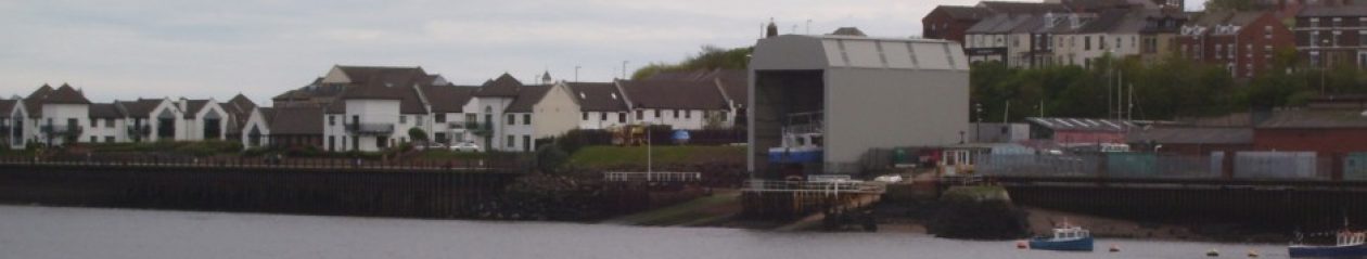
The drawing that was submitted on 11th April 1996 with the application is numbered 8296/1A. That shows the overall height of the structure as 15.5m above the foundation level at the landward end*. At the riverside end the foundations are shown as 2.656m lower due to the gradient of the slipway. The structure would therefore be that much higher at the riverside end.
Variations of this have been repeated many times.
* this is shown in red because the drawing 8296/1A also shows the river end as 15.5m – making the road end 12.5m high. Reference to other drawings and correspondence show that this is more likely to be the height intended when permission was granted.
Denial V
In the email of 28th January the Planning Manager wrote:
8296/14 is the recent drawing and the only purpose of that is in regards to the condition dealing with the strip curtain door fixing details. You explain that you have measured the height from this drawing as 15.6m, and you seem to have assumed that is the riverside elevation, and have adjusted for the gradient of the slipway and concluded that the height at the River Drive side should be in the order of 3m less. In fact the 15.6m height is the height to River Drive and the height on the river side is some 3m greater.
This single paragraph has a page to itself in Denials because in the context of drawing 8296/14 the last statement is simply not true. Note there is no mention of the drawing not being to scale. That opinion comes later when it is pointed out that there are 3 reasons to say that the 15.6m refers to the riverside elevation.