From: Mick Dawson
To: gavin.foster@jpress.co.uk
CC: 26 interested
Subject: Redevelopment of industrial area including UK Docks
Date: Tue, 31 May 2016 07:58:15 +0100
Dear Mr Foster, I wrote to some neighbours about this on May 28th and copied it you because I mentioned a misleading article, in the Gazette attributed to Paul Kelly, on April 1st 2014.I understand he has moved on. I presumed because the Council were feeding him misleading information on the question of the height of the shed, that they had reverted to their position held in January of that year.
The normal channel for corrections is not really available to me now as the article was printed over two years ago. I also know that the Council will say that the shed is built to the approved height because they have been saying that since the development began, Gazette – September 9th 2013. I have checked all the plans available and can show that it is 2.7m higher than planned as well as 0.9m wider.
The correspondence, copied to you May 28th, centred the leaflet “Plan your Borough…” and Mr Mansbridge’s response to our Petition. I wanted to remind people that when plans for designated area ISS4 were being considered that the ‘shed’ belonging to UK Docks had been built without planning permission. I made reference to the most relevant piece of correspondence in this respect.
I realised that you would not have seen Mr Mansbridge’ letter of 2nd May and reproduce the relevant part below:
Dear Resident
Development at UK Docks Ltd, Tyne Slipway, River Drive, South Shields
I am sending this letter to all households in Harbour View, and households between 32 and 99 Greens Place to explain the outcome of the Council’s investigations into the recent developments at the Tyne Slipway in River Drive.
I have endeavoured to answer all the various questions that have been raised with the Council in recent months, including in a petition which many local residents have signed.
The Development Permitted in 1996
Planning permission was granted on 8th July 1996 by the former Tyne and Wear Development Corporation (TWDC) for the erection of a shelter to allow boat repairs to be carried out under cover.
Work commenced to lay foundations and this was inspected by South Tyneside Council’s Building Control service on 26th February 2001. A further inspection on 22nd May 2001 showed that the foundations were fully concreted. This was a material operation for planning purposes in order to begin the development approved in 1996.
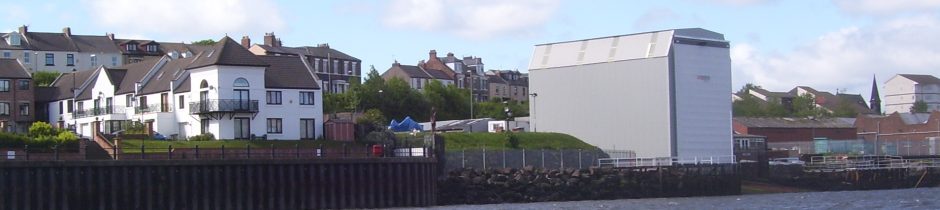
The approved dimensions of the steelwork are:
• Proposed height 15.5m at the River Drive end. The gradient of the slipway is 2.66m over the length of the shelter. This would mean the height at the riverside end would be 18.16m above the slipway;
• Proposed length 22m;
• Proposed width 12.2m.
The measurements which the Council took on 17th September 2014 are:
• Height at the River Drive end 15.5m and at the riverside end 18m.
• Length 22.254m;
• Width 13.1m;
Apart from the width these dimensions are either entirely in accordance with the approved plan, or subject to such minor deviation that they are properly categorised as non-material changes. It was following queries raised in mid-January that that the plans were re-examined. We discovered that the overall width of the steelwork at ground level was shown as 12.2m on the plan, not 12.9m as previously understood.
As I explained on the 28th the approved height is not 15.5m at the road end, it is about 13m and also that the 0.20m deviation on the width is a myth. The Council should have known since their inspection of the footings in February 2001 that they were set 13.1m apart.
In the relevant piece of correspondence, which I hope you were able to access, you will see I pose the question, “What made you determine that the elevation is the South end when there is no such detail on the drawing?” I can tell you that the Planning Manager had to say it was the south or road end because it would have contradicted what he said earlier in his email, “It is therefore reasonable to say that 8296/1A, 8296/1B, 8296/2 and 8296/4 represent the development which was approved in 1996 (the only difference between 1A and 1B being to the foundation detail).”
It is only reasonable to say it, if you take the river end to be 15.5m. I have attached a copy of the plans 8296/1A so that you can see that both ends of the shed are shown as 15.5m. He ascribes the drawing we were talking about, 8296/14 – also attached, to the wrong end of the shed, “In fact the 15.6m height is the height to River Drive and the height on the river side is some 3m greater.” He would have contradicted himself otherwise. I would just like to add that the Council say that drawing 8296/14 could never supersede the previously approved plans in terms of defining the dimensions of the approved development and the Planning Manager would have known that.
It is probable the use of 8296/1A to claim that shed is built to the approved height is not legal. Worse than Mr Mansbridge misrepresenting it in his letter to us, a senior planning officer of the Council repeated it to the Local Government Ombudsman. I think he was actually using 8296/1B, the LGO did not uphold my complaint.
I realise that you may not need to publish correction as you can say that you were only repeating what the Council have been telling you.
Neither Sept 9th 2013 – “A spokesman for the applicant, UK Docks, said: “All I can say is that we have been through all the controls with the planners, and the work meets all the necessary legal requirements.” and April 1st 2014 – “UK Docks has built the 36ft-high boat repair shed at Tyne Slipway, South Shields.” appear to be true and a correction would be appreciated – please let me know what you think.
Kind regards,
Michael Dawson