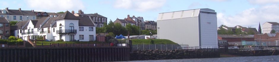
Slipway in 2010 showing an outline base of 27.5m x 13.1m (six pairs of footings)
I realised that you would not have seen Mr Mansbridge’ letter of 2nd May and reproduce the relevant part below:
Dear Resident
Development at UK Docks Ltd, Tyne Slipway, River Drive, South Shields
I am sending this letter to all households in Harbour View, and households between 32 and 99 Greens Place to explain the outcome of the Council’s investigations into the recent developments at the Tyne Slipway in River Drive.
I have endeavoured to answer all the various questions that have been raised with the Council in recent months, including in a petition which many local residents have signed.
The Development Permitted in 1996
Planning permission was granted on 8th July 1996 by the former Tyne and Wear Development Corporation (TWDC) for the erection of a shelter to allow boat repairs to be carried out under cover.
Work commenced to lay foundations and this was inspected by South Tyneside Council’s Building Control service on 26th February 2001. A further inspection on 22nd May 2001 showed that the foundations were fully concreted. This was a material operation for planning purposes in order to begin the development approved in 1996.
The approved dimensions of the steelwork are:
• Proposed height 15.5m at the River Drive end. The gradient of the slipway is 2.66m over the length of the shelter. This would mean the height at the riverside end would be 18.16m above the slipway;
• Proposed length 22m;
• Proposed width 12.2m.
The measurements which the Council took on 17th September 2014 are:
• Height at the River Drive end 15.5m and at the riverside end 18m.
• Length 22.254m;
• Width 13.1m;
Apart from the width these dimensions are either entirely in accordance with the approved plan, or subject to such minor deviation that they are properly categorised as non-material changes. It was following queries raised in mid-January that that the plans were re-examined. We discovered that the overall width of the steelwork at ground level was shown as 12.2m on the plan, not 12.9m as previously understood.
As I explained on the 28th the approved height is not 15.5m at the road end, it is about 13m and also that the 0.20m deviation on the width is a myth. The Council should have known since their inspection of the footings in February 2001 that they were set 13.1m apart. See picture.