When Garlands applied to South Tyneside Council for permission to build their Call Center they anticipated a workforce of about 800 and permission was granted for two office buildings and a large overspill car park:-
Garlands is delighted to announce a major business expansion, with the creation of a new contact centre in South Shields, South Tyneside in North East England. The centre will comprise two new office buildings totalling 47000 sq. ft. within a two acre site.
Construction of the new eight hundred seat centre will be carried out by Mandale Commercial Ltd. and work will start immediately. The centre is expected to open in February 2008. Over a thousand people could eventually work at the site.
Garlands went into administration in May 2010 and the Centre was shut down before they even put the second office in to use. The site appeared to have been cursed because UtilityWise used the main office building for a while but they too went into administration in 2014.
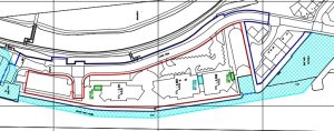
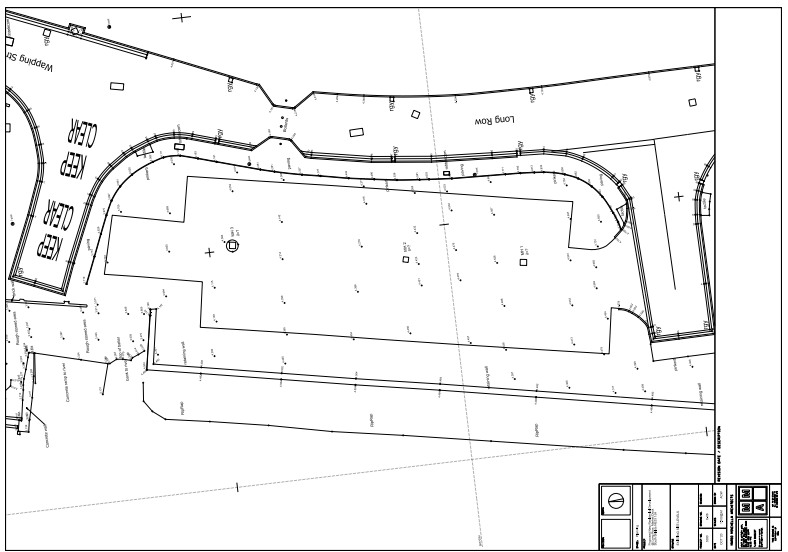
The Call Centre buildings occupied the middle third of the of the section of Long Row shown in the ariel view below. The English Coastal Path ran until some time in 2018 from Wapping Street where it met the river at Comical Corner on the left (north end of view), along the river edge of the car park, along the river side of the two ex-call centre, round the entrance of Market Dock and along to the side Middle Dock where it rejoined Long Row at the point it crosses Middle Dock. It then continued along the side of the river Tyne to the ferry landing for foot passengers.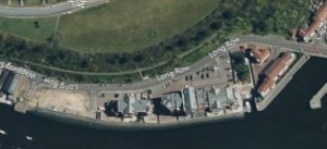
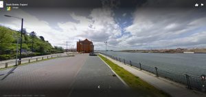 The next view was from Comical Corner from about the time that the Call Center was lying empty.
The car park was barely used even when the Centre was in use and only ever had an occasional visitor for many years. Then the bricks that had been laid to make it started to disappear and that is the bare patch on the left in the first view.
 The boundary at the south end of the former call centre was clearly marked by what used to be the north edge of what used to be the small dry dock which was made into a communal space, with seating, by the Council.
The line of the English Coastal Footpath was indicated by the railings provided for the benefit of those who wished to walk beside the river and they ran from near Comical Corner to what used to be Middle Dock.
1
Loss Of Amenity
The site plan is taken from ST/0088/17/PNCU and to quote:- “Application for prior approval for the proposed change of use of existing offices (Use Class B1a) into 43 two-bedroomed residential apartments/duplexes (Use Class C3) under Schedule 2, Part 3, Class O of the Town and Country Planning (General Permitted Development) Order 2015.
The Applicant was Keywest Three Ltd.
The Agent was Mario Minchella Ltd.
The Planning Officer was Garry Simmonette 0191 4247426
Notice the site plan prepared in 2015, the red line, includes a lot more than the two existing blocks that were UtilityWise. It also includes the car park to the north or left on the drawing below, Market Dock to the South (right hand side) and the English Coastal Path from Comical Corner at the north end, to where it turns back toward the river after crossing what is left of Market Dock. The southern boundary of the old UtilityWise site is shown as including the Dock.
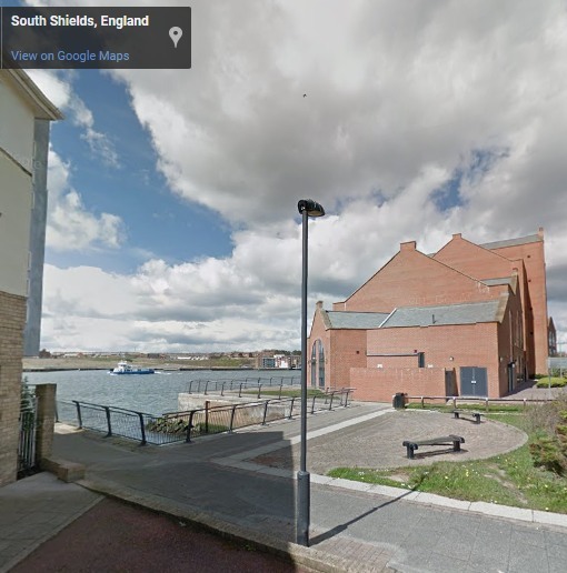
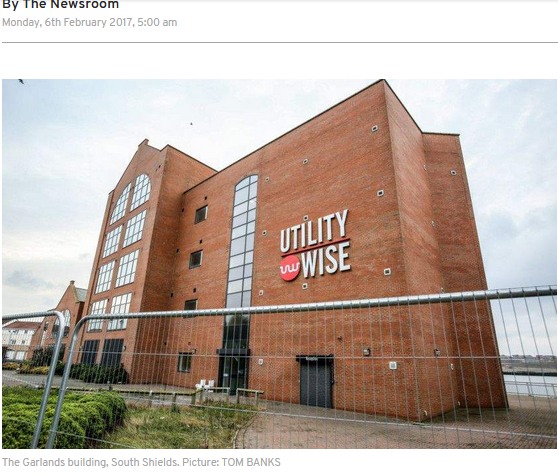 UtilityWise February 2017, (Gazette), showing neatly paved area at its northern end and includes what was to become the English Coastal Path running along side the river (bottom right).
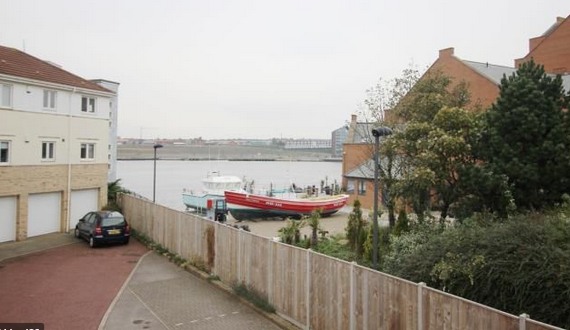
 The same location from a different perspective, four years later. The English Coastal Path is blocked by a well fitted permanent fence and its paving has been removed but the railings are still there.
There is still access from the public highway as one can see from the car parked neatly out of the way. The outline of the location plan is shown in red and the indent on the eastern side of it shows were the bit of the road with double yellow lines fit into the whole picture and poses the question – who owns the car park.
2
 At the other end of the former Call Centre the Council had originally provided a pleasant seating for the use of the local residents and those using the English Coastal Path. See foot of page 1.
As one can see from the later picture of Market Dock, the seating and the street lights are still there. The whole of the filled in part of dry dock appear to have been given away by the Council to Key West Ltd and at the same time the owner of the nearest flat has been able to fit a boat lift for his exclusive use into the bit of the dock that is still open to the Tyne.
Not only that the path that went on to run in front of Nos 14 to 21 Long Row have also been given to the current owner(s) of the former UtilityWise site and there is now a 2m fence put there to exclude the public from the former seating area.
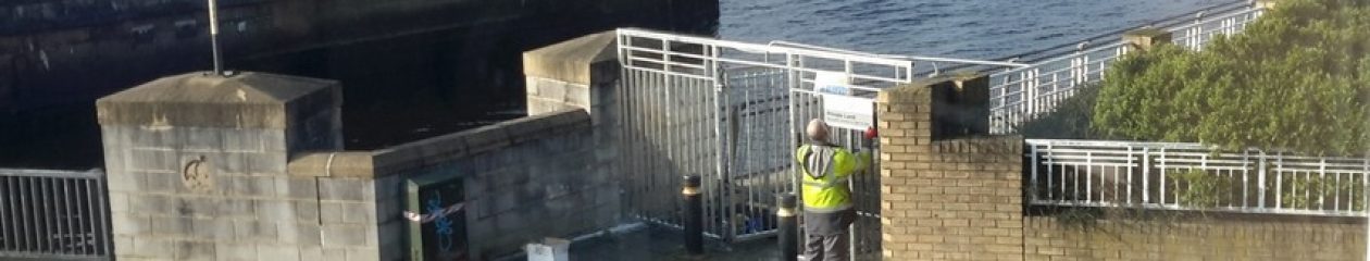
The loss of amenity was completed when the Council allowed the former public footpath which was part of the English Coastal Path to be gated. It is no longer in the public domain. In the plans drawn by the agent for Keywest Three Ltd, the path formally the most southern bit of it, shown within the extended area indicated by the blue lined area from ST/0088/17/PNCU.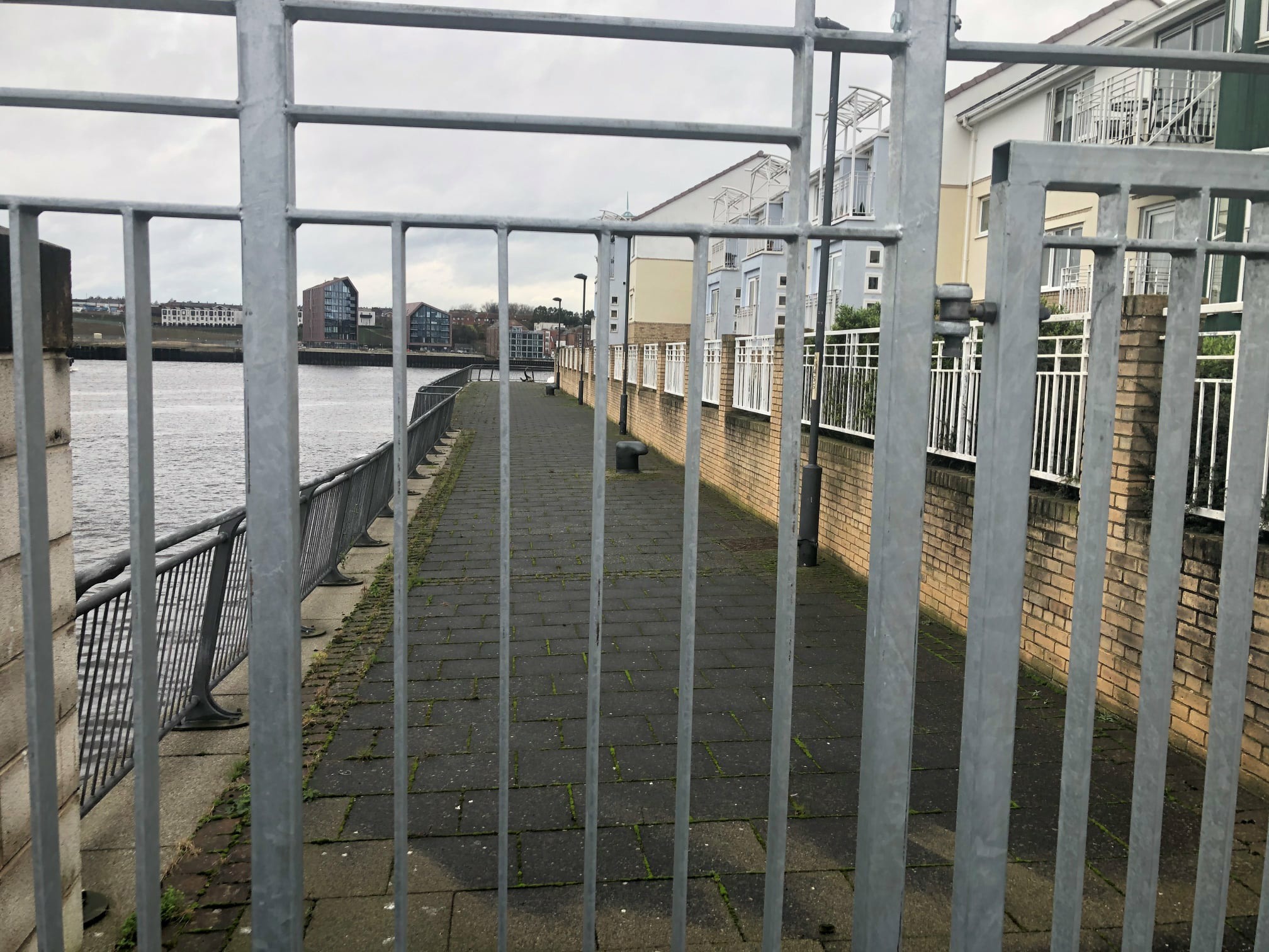
Plans for the Car Park
 It appears that agents for Keywest No. Three Ltd, had laid claim to the car park. Please see the plan made by Mario Minchella Architects in October 2020. The railings that used to run along side the English Coastal Path are attached to the top of the retaining wall which runs along the river side of the car park.
3
The barrier round the Long Row/Wapping St side of the car park, see the view from Comical Corner on page 1, is clearly shown and one had to step round the end of it to get to the footpath which is not clearly shown on the plan. As you can see the grass edge and the footpath have been merged by the architect into one into one although he has taken care to to show the retaining wall.
By the time the plans were submitted to the Committee on August the 31st 2021 the agent had redrawn the plans to show that the public footpath that used to be at the river’s edge could be completely blocked off.
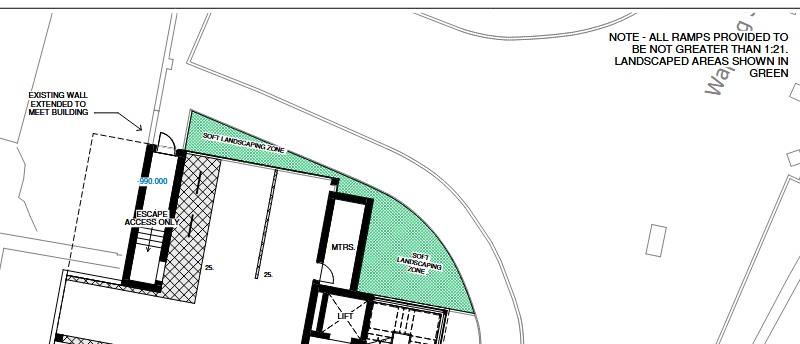 Plans to close off access to it were submitted by the Agent/Mario Minchella Architects 30th June 2021 and the north end closure is shown here where the external wall is extended to meet the new building.
Keywest No. Three plan to close off access by the public by the planned extension of the existing wall to meet the corner of the proposed block of flats.
At the other end, Keywest No. Three plan to close of access to the former footpath which will become a ‘residential amenity area’ by the use of a SECURITY GATE FOR MAINTENANCE ACCESS ONLY. The former English Coastal Path that used to run along side the river for the benefit of all had been shut off at the request of new owner of the car park.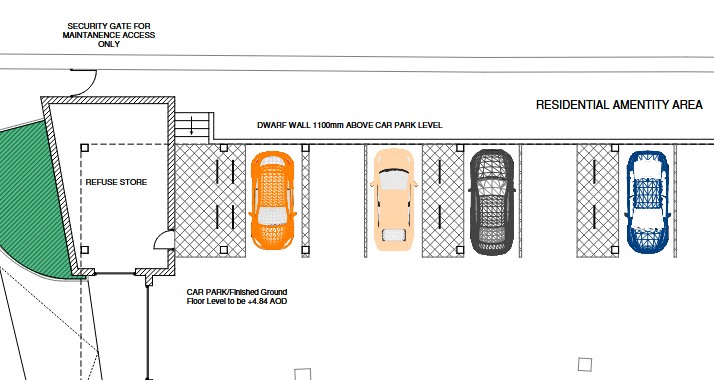
These plans were put forward by Helen Lynch and approved by Peter Mennell in August 2021 and they appear to be treading along a path devised by the Principal Planning Officer, Peter Cunningham in 2013, see Readheads Landing, below. They were refined by Planning Officer, Gary Simmonette and the Head of Development Services from 2017.
Readheads Landing
 The Principal Planning Officer in charge of closing access to the river Tyne from Readheads Landing did it in 2013 and appears to have got away with it, because access to waterways is very ancient and appears to be controlled by Parliament and not by the Local Council. However public river landings are not liked by Port of Tyne or South Tyneside Council because while having to maintain them etc. they do not profit from them.
Meanwhile there was still a need to maintain the navigation into Tyne Dock because of Tyne Slipway and Engineering Co. Ltd, which employed a number of skilled craftsman and that included those who maintain the Port of Tyne’s pilot boats and the Shields Ferries. The Port of Tyne wished to close Tyne Dock completely for the expansion of their woodchip import business so they needed to find a new home for the maintenance of their pilot boats.
The Port of Tyne wished to close Tyne Dock completely for the expansion of their woodchip import business so they needed to find a new home for the maintenance of their pilot boats.
4
By 2013 there was only two slipways left in use on the Tyne and they were the one in Tyne Dock and the one off River Drive in South Shields. At some point the owners of the River Drive site had applied for permission to build a cover or enclosure over the slipway and it was granted by the Tyne and Wear Development Corporation in 1996. It would not have been economically viable and although the foundations were laid in 2001 the shed was not built because the footings were for a bigger shed than the one for which they had permission.
It transpired that a taller shed and longer shed was required to accommodate the ferry and a solution to this problem was provided by South Tyneside Council who simply turned a blind eye to the fact that Tyne Slipway & Engineering Co Ltd built a far larger boat shed than was permitted so that the business could be moved from Commercial Road to River Drive. While the shed for which they had permission would have held a Port of Tyne pilot boat it would not have held the Shields Ferry.
By the time the local residents raised complaints about it being bigger than planned the boat repair company had re-badged itself as UK Docks and to hide the fact that the shed was nearly 3m taller than it should have been, they gave the Council some dodgy plans to support their fraudulent misrepresentation about the shed’s height – see pages 1 and 2 of Shed and Corruption Part 1.
The footpath between Commercial Road and the former Landing no longer served its original purpose and ended up as part of the Port of Tyne estate. One could say that South Tyneside Council had given it to the Port of Tyne or more accurately, a Principal Planning Officer had given it to them.
Conclusion
Ancient and not so ancient parcels of land are given to property developers in this way. They do not own these but as soon as the Council approve the adjacent development the ownership of the lane, footpath or Right of Way, appears to pass to the developer.
Protest appears to be a waste of time because the Planning Officers and Enforcement Officers appear to be acting on behalf of the developers and not for the local residents and after many years, the device of giving public footpaths away has been refined to such an extent that they can bypass a Planning Committee completely and convince the Land Registry that the ownership/responsibility of that section of the English Coastal Path, either side of Market Dock, had passed from the Council to Key West No Three Limited.
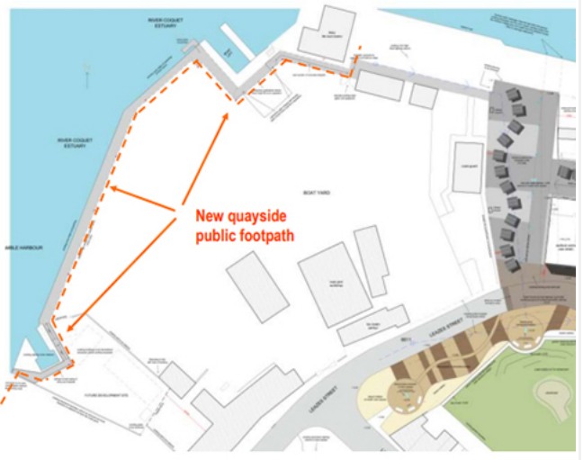 In 2013 the Quayside public footpath was set up to connect the Harbour Village with the existing footpath across the Braid and it was to follow the quay-edge along Coble Quay and through the premises of the Amble Boat Company Ltd.
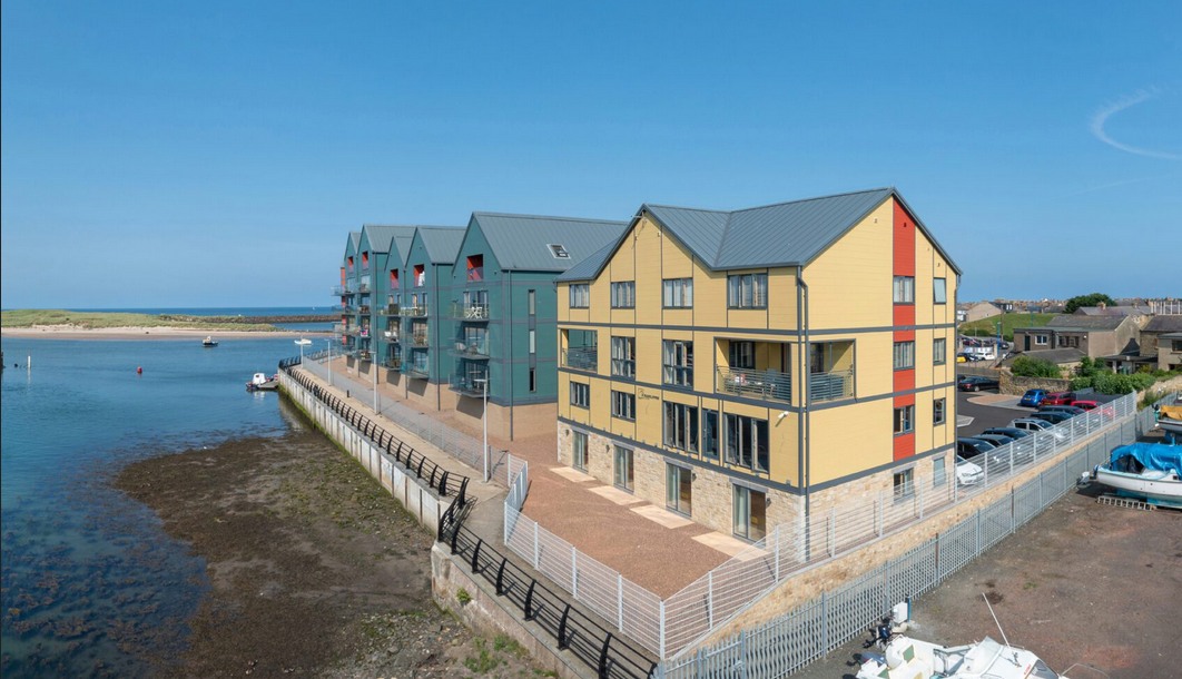
 It also shows the slipway that was used by both the sailing club and Shore Base and was included in the location plan for the marina. Amble Marina were given neither the path labelled:- Entrance to coquet shorebase. (existing) which points directly to the slipway, nor the car park adjacent to the garage in the detail given at the foot of page 1.
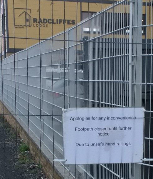 The car park was still free in August 2022 but by that time access to the side of the marina and onto river Coquet had appeared to have been denied? The slipway shown as part of the sailing club became useless for many years as the only access to it was from the public footpath that ran from Coquet Street to the corner of the marina.
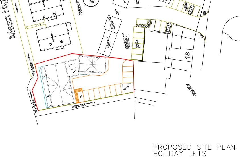
 Application – 21/03580/ADE, 08-Sep-21
 The footpath, previously shown as a promenade, was clearly not included in the development that included the four blocks of flats but the footpath serving the former slipway was, by September 2021, shown as belonging to owner of Radcliffes Lodge.
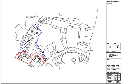
 The three blocks of flats duly appeared with the footpath between the new flats and mean high water sill extant but the one between them and the Sailing Club had gone and it looks like the development had been built over the footpath but it had not. It is still there, see The English Coastal Path – Amble, August 2022 on the page below.
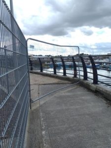 The second Application
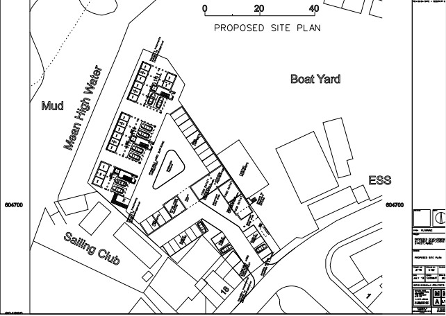
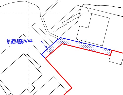 The drawing A-00 (Project 3314), prepared for Mr Tweddle by his architect in February 2020, shows a 3m wide
 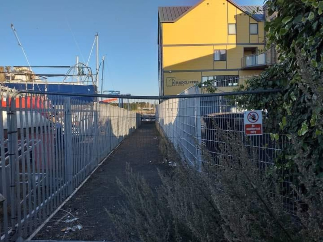 I had written to the NCC in Sept 2021 about the closure of footpath between Radcliffes Lodge and the Amble Marina boat park but the response showed that they had clearly sided with
 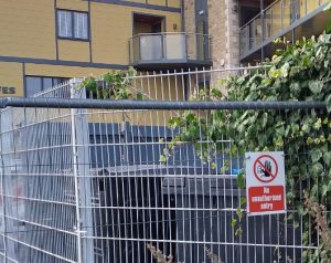 He should have been reminding whoever was responsible for repairing the railings to get it done, rather than
 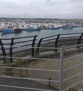 It would appear that neither the owner of the Marina nor those who own Radcliffes Lodge wished to be responsible for the damaged handrail and their solution is to deny access to the public and in this they were aided by an NCC enforcement officer.
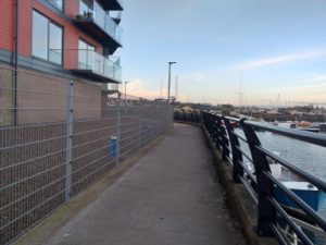 It would appear that when the final development to turn the last boatyard on the North East Coast into a private estate of luxury housing and lets, another one of those, No Unauthorised Entry signs will get attached to yet another barrier to the English Coastal Path.
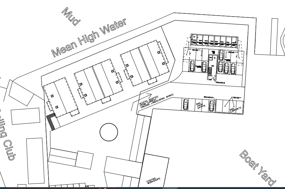