The response by the Principal Planning Officer to the complaint about the breach of the second condition was not satisfactory, it appears to be a denial that there is anything wrong and I ask him: “If you are unable to supply me with answers to my questions could you please pass the issue to someone who can” and he, the Planning Manager in his first response:
- repeats what the Principal Planning officer told us in December 2013: “The dimensions of the steelwork have been checked on site and they are in accordance with the measurements shown on the approved drawings.”
- introduces 8296/1A (…/1A) implying that it an approved plan but if look you will see he is very careful not to put it in writing. The drawing is not approved presumably because it shows both ends as having the same height of 15.m.
- introduces 8296/2 as one of the two approved drawings from 1996 but fails to say the the only dimension given on it shows the landward end is approved at 12.7m.
- that means that anyone using 8296/1A or 1B to claim that the shed was built to the approved height was repeating a fraudulent misrepresentation.
This drawing ( ../1A) and the ones which Mr Cunningham sent out gives both the river end and the landward end the same height indicating the roof should slope down towards the river with the same gradient as the slipway. It does not, so one of the end height dimensions must be wrong and careful examination shows that it is the road end. He has ignored the use of ../14 in the complaint which confirms that the road end should be 12.5m or 12.7m.
I write again on 24-Jan-14: You have informed me that the width of the structure has been measured, but have not stated the dimension or informed me that my measurement is incorrect.
~~~~ And ~~~~
It should be pointed out that the agent is bound to consider drawings that have been authorised and that the approved drawing 8296/14 confirms a lower height for the landward end which was why it was used in the complaint to show the a planned height of the river end of 15.6 meters and the width, across the supporting columns, 12.2m but the planning manager ignores and in his second response tries to reintroduce ../1A again and misinforms the reader about ../14. See below:
- “it is reasonable to say that 8296/1A, 8296/1B, 8296/2 and 8296/4 represent the development which was approved in 1996 (the only difference between 1A and 1B being to the foundation detail). – it is not reasonable to say either ../1A or ../1B have been approved. It is more likely that they have not been approved because they contain errors.
- 8296/14 . . . you seem to have assumed that is the riverside elevation. . . . In fact the 15.6m height is the height to River Drive and the height on the river side is some 3m greater. – the gable end on this drawing ‘Strip Curtain Doors’ is of door to the river; the boats come into the boathouse from river not from the road.
These are gross misrepresentations particularly the inclusion of 8296/1B in the first statement. It is a fact that the elevation on 8296/14, not an assumption, and the cover is in breach of the 2nd condition. The Planning Manager also fails to answer satisfactorily the last 4 questions.
- Why are there no date stamped and approved plans available on the planning portal?
- Why are there no plans for the current structure?
- As the applicant has not discharged condition 2 why is there no retrospective planning
application? - Why when I have been provided with a drawing dated 1996 were residents informed Council was not involved at this time?
In answer to your four final questions:
1 While basic details of the 1996 application can be accessed on the Planning Explorer website (reference ST/0242/96//UD) drawings and other details are available only for much more recent applications.
2 The details of the approved drawings are given above.
3 Condition 2 does not require any submission by the developer.
4 In 1996 the Council was not the Planning Authority; that was the Tyne and Wear Development Corporation (TWDC). The Council received applications on behalf of TWDC.
I trust that this assists you
Planning Manager
South Tyneside Council, Town Hall & Civic Offices
- yes – but they tell us that they have recovered UK Docks plans from the archive.
- although he discusses 8296/1A under the heading ‘Approved Drawings’ he does not actually say it is approved. The only approved drawings giving heights mentioned above are the Agents drawing ../14 and from 1996, 8296/2. There is no evidence that 8296/1A has ever been to T&WDC let alone been approved;
- yes – but it still requires that the cover is built to plan.
- the Council were sent date stamped authorised plans after approval and only one with dimensions on survives. It is 8296/2 and it contradicts what the Planning Manager is telling us. It gives a height of 12.7m for the landward end.
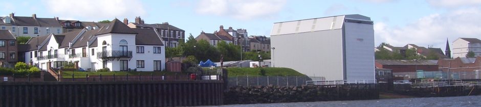
When he concedes the point about the the structure not built to approved plans he also says that he engineer chose to show a gable elevation of the structure (not drawn to scale) on the same drawing. This is the drawing that I used to point out to the Council that the cover was nearly 3m too high because it was drawn to scale; it gives a detail of a beam (portal column) width 0.686mtres, with which the height and width of the north elevation can be gauged. The drawing is fairly accurately drawn to a scale of 1:100 and the gable on the full sized drawing is 16cm high.
He has worded his response to make the reader think that only the width is being considered when in fact we were talking about the height and we are now we are now back to the the impasse we had with Mr Cunningham and the meeting of 25-Nov-13 except the Planning Manager has added two items of misinformation:
- the height of the inland or road end has an approved height of 15.5m
- that the drawing of the gable end on the agent’s drawing 8296/14 is not drawn to scale.
On top of the misinformation he goes on to suggest that if I wish to pursue this matter further I ask that his Head of Service, George Mansbridge to respond to any remaining points I may have formally under stage 2 of the Council’s complaints procedure. This is the second misuse of the complaints procedure to be practised on me and two misrepresentations have been aired which are later repeated as facts to the LGO.
I’m aware that he has crafted his responses that he can present any of them to claim that there is little or no variation from plan and no action need be taken because of the breach so I thanked him for confirming that the Slipway Shed is not built to the approved 1996 plans. The only approved plans from 1996 with measurements show the planned height of the landward end of the cover to be 12.7m
However it became clear that the Council had quickly reverted to the view held before the complaint about the breach, 10-Jan-14 because:
- the Case Officer was telling people that there was little or no variation in either the height nor the width, unfortunately we have nothing in writing;
- UK Docks had taken Port of Tyne Tug onto the slipway 17-Mar-14;
- article in the local newspaper 1-Apr-14.
It was as if though all my correspondence with him had been deleted from the records and it may as well have been because he had not used the complaint (Job Number 248789) on any correspondence till 25-Apr-14.
From: Gordon.Atkinson
To: M Dawson
Date: Fri, 25 Apr 2014 12:43:07 +0100
Subject: feedback case 248789
Dear Mr Dawson
I’m sorry for the delay. Mr Mansbridge is hoping to get a comprehensive response off to residents by the end of next week.
Regards
Gordon Atkinson