Northumbria:
From the route description given in www.nationaltrail.co.uk the section of the England Coastal Path (ECP) that should most concern those in the North East of England and who care about such things, lies roughly between the Tees and the Tweed and while bits of it have been given to developers/owners of luxury flats on the banks of the Tyne over the last four or five years the way is being prepared for this to be repeated on the banks of the Coquet in Amble.

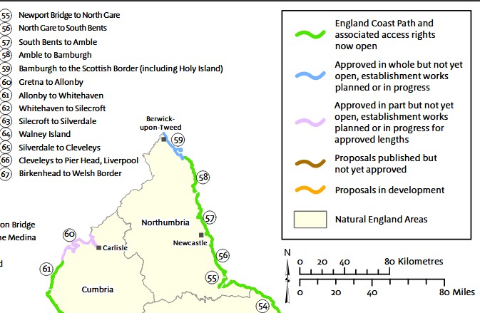
The tenth section of the England Coast Path, to open, provides walkers, amblers and ramblers with uninterrupted access to 44 miles (71 km) of beautiful coastline between South Bents in Tyneside and Amble in Northumberland.
South Bents is where the South Pier at the mouth of the Tyne intersects the beach facing the North Sea and the beach more facing the Tyne.
Both the Tyne and Coquet force the England Coastal Path to turn inland for a mile or so until a crossing can be made. In the case of the Tyne, it is the Shields Ferry and the north side of the Tyne is still a pleasant walk relatively speaking and it appeared that a similar plan had been prepared for the south side by South Tyneside Council (STC). There were however a number of boat yards and slipways that needed to be navigated round.
There are two slipways which illustrate the double standards of the Local Council. In 2013, STC turned a blind eye to the closure of the slipway by the Alum Ale House yet accepted non approved plans from UK Docks* to build a shed on their slipway off River Drive. That slipway appears to have been ‘given’ to the Wilson family, some time in in the 1990’s and the business is still in the family and runs as UK Docks.
Bits of it have now disappeared behind luxury housing developments where it turns inland at the mouth of the Tyne to meet the Shields Ferry Landing. For detail about the stoppage at the other end, please see Disappearing Footpath 1.
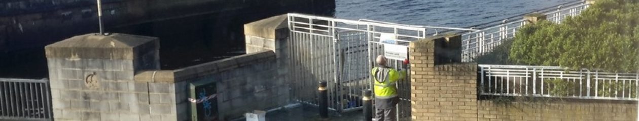
Another bit of the England Coastal Path is going to disappear where it turns inland at the mouth of the Coquet at Amble.
 Not only behind some luxury housing but behind Radcliffes Lodge as well.
Northumberland County Council have no wish to do anything about it and one will have to ask one of their enforcement officers, why they are content to sit back and do nothing while letting the directors of Amble Marina and Radcliffes Lodge leave the broken fence as a hazard to those still wishing to use the England Coastal Path.
The Coquet forces it to join the the A1068 before the hill into Warkworth but it appears to resume its way North again with the path that comes out beside the Castle Brew House attached to the Sun Hotel a couple of hundred yards to the north.
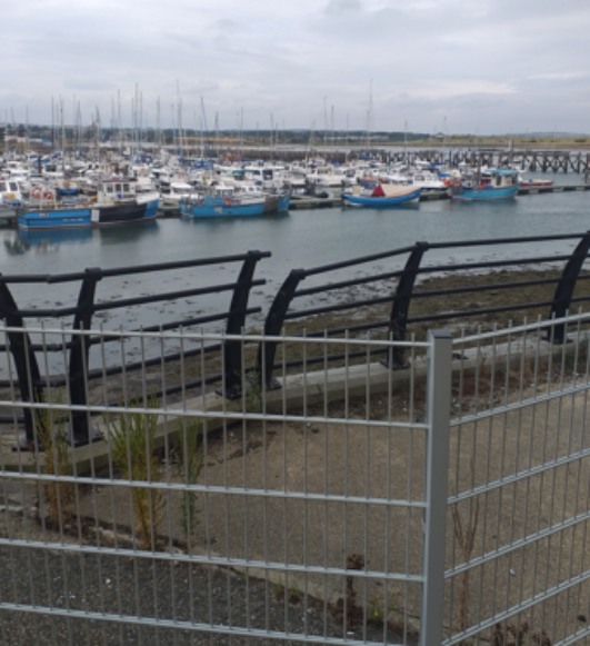
The footpath leads down to the river Coquet and over the bridges in Warkworth and if one takes takes the first right after crossing the river, one can gain access to a very quiet beach which is highly recommended. The way onto it is via the golf course. The way off at the north end is more problematic as wading the Aln is not to be recommended but by then we are far away from footpath that ran along the side the Amble Marina until a year or so ago.
It looks from here that the planning/enforcement officers of Northumberland County Council are preparing the way forward to give the promenade running alongside the marina to the owners of flats and the owner of Radcliffes Lodge much as the planning/enforcement officers of South Tyneside Council gave the footpath to the owners of 30 and 31 Long Row, five years ago.
Both sets of planning and enforcement officers hide behind the issue of whether either the bits now missing from the England Coastal Path are Public Rights of Way or not because to avoid the the issue that both that in South Shields and that in Amble had been adopted by the respective Councils.
A letter from the Public Rights of Way Officer appears to confirm that the one in South Shields is not a Right of Way and a letter from from the enforcement Officer of NCC shows that he knows full well that the bit of the King Charles III England Coastal Path now being blocked in Amble is not a Right of Way either but one will still need to ask why the barrier to the walkway beside Amble Marina is still there, years after the issue was raised with them.
* there are two approved drawings listed, 8296/2 gives the height of the landward end as 12.7m the height at the river end can be found from 8296/14 as the river end is drawn to scale of 1:100 and the conversion of mm to meters is simplicity itself if one was working from a full sized drawing it would give 15.5m. No-one in ten years has ever disputed the notes made on 8296/14 by Mr M Dawson in December 2013.