UK Docks, River Drive Slipway Enclosure – Plans and Drawings
Condition 2 of the grant made in 1996 states: “The development to which this permission relates shall be carried out in complete accordance with the approved plans and specifications.”
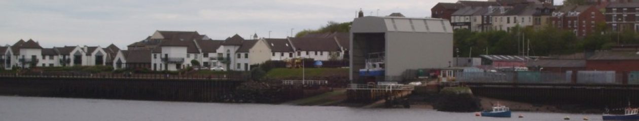
The Council said the measurements of the frames were taken in September 2013: L = 22.254m, H(river end) = 18m, H(road end) = 15.5m and W=13.1m.
We were not told what they were until the end of January. Until then, the Council said the enclosure was compliant and it appears that they would still be repeating that fiction if we had not measured the width by simple surveying from Greens Place and found it to be nearly a meter wider than planned.
It was apparent to the residents that the variation in planned height was same as the gradient but it was not until the drawing 8296/14 produced by Maughan Reynolds Partnership (agents), to meet condition 4 that we were able to demonstrate to the Council that the enclosure was 2.7m too tall. The the drawing was not in the public domain until December 2013.
The plans and drawings for the enclosure fall into two groups:
Ones that are not approved:
- The pair of drawings (longitudinal section and 8296/1B) presented to the Council on September 6, 2013 by UK Docks;
- The drawing held by South Tyneside Council since April 1996, 8296/1A which shows a dimensional error at the landward gable end and bears no evidence of having been to the T&WDC;
- The pre-planning sketch made by UK Docks (ST269696).
Ones that are approved:
- 8296/2, and 8296/4 authorised by Tyne and Wear Development Corporation (T&WDC) in 1996 and 8296/14 presented by the agents and approved by the Planning Manager of South Tyneside Council in October 2013.
- 8296/14 produced in August 13 and Approved in October 13.
The following drawings have been left out because their inclusion is of little relevance except to say it does however suggest that the shed is just over 12m at the road end and 15m at the river end (they have overestimated the gradient by a couple of meters).
- 8296/4 is dimensionless and only shows the layout of the translucent panels;
- ST269696 looks like a pre-planning sketch made by UK Docks. It was the drawing first used to question the height of shed and led to the reforming of the Tyne Gateway Assn because the Principal Planning Officer refused to say whether 12m was the planned height.
Longitudinal Section and 8296/1B
There is no evidence that these have even been seen, let alone authorised, by the T&WDC. 8296/1B which was an amendment to 8296/1A shows:
- it was drawn in February 1997 and it is doubtful if it is ‘legal’;
- the height is missing from the road end of the unnumbered drawing;
- the river end is shown to be the same height as the landward end at 15.5m high which is an impossibility considering the gradient of 2.656m(2.7m). The width is is also missing from from the top of the river end section.
The Council maintain that the landward end is correct, giving a river end of 18.2m. One could say with more conviction that the river end is correct giving a landward or road end of 12.8m.
If one views the landward elevation (bottom right of page 2) in a ‘pdf’ viewer at 150% (scale 1:100). The measurements are 3 and 10cm, not 3 and 12.5cm, which equates to a total height of 13m. If that does not suit then one can use the gradient of 2.7m from 8296/1B in the ‘longitudinal section’ to estimate that the ends are 16 and 13m which, again, agrees with any view other than that of the Council or UK Docks; that the planned height of the landward end is about 13m.
Please note – the arguments just outlined also apply to 8296/1A.
8296/2
This is one of two drawings made in 1996 that have been authorised by the T&WDC as can be seen from the complete copy. This was retrieved from the Council’s archive in September 2013 but not made available for comment until the end of January 2014. This shows details that are missing from the ‘longitudinal section’ sent into the Council by UK Docks:
- drawing number, drawing date and T&WDC authorisation stamp;
- the height of the roof top above the datum (118.8m)
- the height of the base above the datum (95.5m).
The height of the landward end on this drawing is therefore 13.3m and the river end 2.7m more (16m).
8296/14
This drawing was produced as part of a submission to the Council by the agents, Maughan Reynolds Partnership, to meet condition 4. This drawing was produced in August, received by the Council in September and approval given by the Council 13-Oct- 2013.
The additional notes show dimensions as 15.6m x 12.2m and these were originally made from an A4 copy. If the A1 drawing which should be held by the Council is examined, one will see that the gable is drawn to a scale of 1:100 and is 16cm x 12.5cm. This shows a planned height of the river gable end of 16m and the Council’s legal section has said the drawing could never supersede the previously approved plans in terms of defining the dimensions of the approved development. Its publication in December 2013 should have finally put paid to the argument about which end of the enclosure had a planned height of 15.5m and it is not the landward end.
Conduct
The Council have successfully maintained the myth that the planned height of the landward end is 15.5m by saying or suggesting that 8296/1A or 1B are approved, and quoting a dimension that is specified incorrectly. They also ignore the fact that both drawings give the river end a planned height of 15.5m as well as the road end.
When 8296/14 is mentioned the Council say things like it is not to scale and it refers to the road end, both of which are lies. They also said that on completion there is to be the opening on each of the gable ends. True, there is indeed an opening at the landward end and it is there to allow workmen and goods into the enclosure and is not much bigger than a standard domestic garage doorway. It is not the portal shown on 8296/14.
Misrepresentations such as those just outlined in the last two paragraphs has enabled the Council to misinform the residents of Green Place and Harbour View in the response to a Petition.
This strategy also enabled the Council to misinform the Local Government Ombudsman (LGO) so that the complaint about the variation on height was not upheld and they were then in a position to use the LGO’s decision to misinform other interested parties such as Members of Parliament.
It is worth noting that when they quote the LGO they omit the last part of the summary:
“The complainant says the shed is also 3 metres higher than it should be. The Council says it is not. There is no fault in how the Council decided the shed is the permitted height.”
The Council have not been able provide any approved plans that will support this decision yet deny that the Local Government Ombudsman has been misinformed.