Why did we determine the elevation on 8296/14 is the south end?
This question can only answered truthfully by saying “because we were wrong”. It is not the south or road end, it is the river end because it has a door to let the boats in.
In fact the 15.6m height is the height to River Drive and the height on the river side is some 3m greater.
To put it plainly – he is wrong. In this context we are referring to drawing 8296/14 and there are three pointers to indicate that the drawing is of the river end elevation. I have to write again to point this out to him.
And you seem to have assumed that is the riverside elevation.
It is obvious that the elevation is the riverside end of the shelter. There are three pieces of evidence that show the elevation is riverside elevation; it is not an assumption:
- Detail note on the drawing, “strips to draw back to each side to allow access for
boats”;
- The section at the door jam shows the cladding on the downward ie. North/river
end. The alternative would have the cladding on the inside of the building;
- The apparent use of third angle projection would imply that the door is at the north end.
The only difference between 1A and 1B being to the foundation detail.
Not quite true, see item 1 in list below:
- 8296/1B shows an amended date of Feb 97, 6-7 months after the grant of permission
- it shows frames of the same size – not of increasing height down the slipway
Following a search of our archived file the only drawings that we have that are stamped ‘Approved by Tyne and Wear Development Corporation’ are 8296/2 and 8296/4.
These have been available to view since Sept 11th 2013. Although the staff at the town hall have allowed inspection of the discs it is very difficult and copies have not been allowed, see disc viewing by Paul, Nov 2013. These are the first issued to anyone outside of planning.
8296/2 is a scale drawing and tends to support the argument that the shelter is 3m too high. Using the gradient (2.656m drop along the length) the road end and river end work out to be 13m and 16m respectively. Review III.
8296/4 is an illustration of the translucent panels and is not to scale.
the company provided from its own sources copies of drawings numbered 8296/1B and 8296/2
Neither of these two drawings show authorisation details, 8296/1B is drawn six or seven months after the grant of permission and 8296/2 is truncated and shows no number nor height details. From the length of the shelter on the site elevation (page 1 of pdf file) one can estimate that the heights are 13.5 and 16.5m.
This drawing is stamped ‘Approved by Tyne and Wear Development Corporation date 8/7/96 22/8/96’
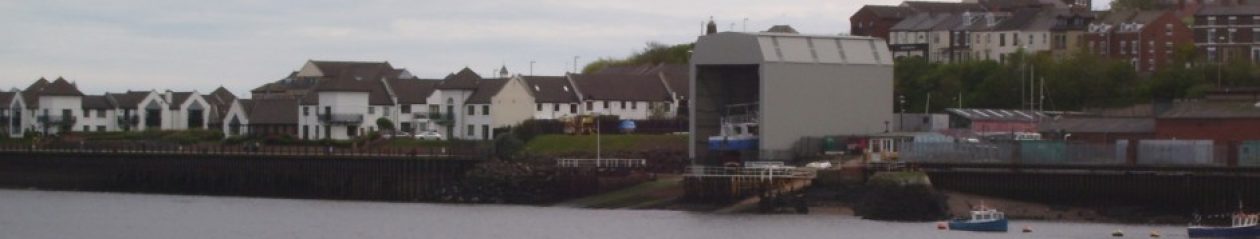
A second drawing was received by TWDC on 4th June 1996 from the developer’s agent. That is numbered 8296/2. This shows longitudinal and transverse sections through the site to illustrate the relationship between the proposed building and the gradient of the site, the riverside revetment and existing buildings on the site.
Using either the fact that the gradient is 2.565m or the length of shelter is 22m long one can work out the height of the ends.
The road end is 13m and the river end, 16m. This is further substantiation of the planned height of the shelter is 12.5/15.5m and not 15.5/18.5m.
- That shows the overall height of the structure as 15.5m above the foundation level at the landward end. At the riverside end the foundations are shown as 2.656m lower due to the gradient of the slipway. The structure would therefore be that much higher at the riverside end.
- He omits the fact that drawing 8296/1A shows quite clearly that the height of the river end is also 15.5m. Both ends cannot be 15.5m high if the roof top is level and there is a gradient of 2.656m. Careful examination of 8296/1A shows that the river end being 15.5m high is a more likely explanation than the Planning Manager’s of the road being that high.
The Planning Manager has been disingenuous in his explanation and it does not stand up under investigation. Variations of this have been repeated, principally by the Head of Development Services and he uses it as the reason to take no action, he maintains there is no material difference in height, against UK Docks for not building the shelter to plan. It also appears under various guises in correspondence over the next 15 months:
- letter to residents
- stage 2 response
- stage 3 response
- decision by Local Government Ombudsman
Drawing 8296/14
The Planning manager said at the end of the paragraph on drawing 8296/14, “The north elevation is 15.6m high with a width of 12.2m.” He is totally wrong – the north elevation is the landward or River Drive end of the shed.
The detail is the downward end, south end or river end.
- the cladding is on the outside
- note saying . . . . to allow access for boats.
Examination of this drawing number (8296/14) gives a detail of the beam and portal column, depth or width of 0.686m, with which the height and width of the north elevation can be gauged(15.6 and 12.2m). This means that the other end, south or landward or road end, would have a planned height of 12.5m.
built without planning permission