When the Planning Manager could no longer defend the Council’s view that the cover was built to plan, and we are talking about it being 3m too high here, he asked me if I felt the Council should be taking some action if it has not done already, and to let him know what that should be.
I broadcast our last 3 emails to the local community, you need all three to get the context, and a meeting was arranged to decide what to do. There were 30 or so people at the meeting at the Little Haven Sailing Club and we decided to raise a Petition and I would write to the Planning Manager which I did the following day to answer his question as to ‘what kind of action we would like the Council to take’.
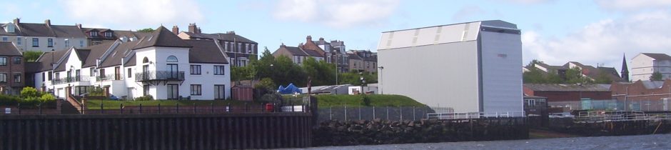
The first thing I do is to thank him for confirming that the Slipway Shed is not built to the approved 1996 plans, knowing that is the only plan held by the Council that we have seen with dimensions. It shows that the slipway cover is nearly 3m higher than planned.
The immediate response from residents was to request the slipway construction be removed. However the universally agreed request of Council, is that there is immediate cessation of work on the Slipway Shed until such time as appropriate community consultation with the relevant council departments can be arranged. MD 4th March 2014
Within a few days we hear that the Council were telling enquirers that while they agreed that the structure was taller and wider than the one for which permission had been given, there was not enough difference to enforce removal etc. This explains why the Council had allowed work continue on the shed since January 2014.
They could do this because the Principal Planning Officer had removed the complaint of the 10 January from Planning Enquiries. He did this do that he did not have to answer the question: “As the applicant has not discharged condition 2 why is there no retrospective planning application?
On the 17-Mar-14, a Port of Tyne tug was taken onto the slipway and into the cover which still had no end panels in place. A clear breach of condition 4 and naturally we complain but to no effect because the Shields Ferry is taken onto the slipway six weeks later, its bow poking out of the shed by a meter or two. This action reinforces our view that the Planning Manager was telling the residents one thing but the people who have to make decisions another. No enforcement action was taken in spite of the height difference from that permitted.
That a reversion on height was taking place was confirmed by an article that appeared in the local paper on 01-Apr, a rewrite of one they did about the cover in September. It looks like the Council are not being entirely honest with author of that article but I’ll leave that for others to judge. One would have thought that the discrepancy in the height would have been corrected.
The article repeated the most telling remark made by a spokesman for the applicant, UK Docks, who said:
“All I can say is that we have been through all the controls with the planners, and the work meets all the necessary legal requirements. All we are doing is going ahead with the previous planning permission.”
They were not going ahead with the previous planning permission. It was only ‘legal’ because the Enforcement Officer has not asked UK Docks to remove or replace the frames with ones of the correct height and width. Apparently one can erect a structure without planning permission and it does not become illegal until told to remove it or rebuild it.
The reversion by the Council is confirmed when we receive the response to our Petition and our stage 2 complaints from the Head of Development Services, Mr G Mansbridge. He cites drawings from 1996 which are not approved and uses them to claim a planned height of the road end of 15.5m when this has been shown to be indefensible. Only one end of the cover can have that approved height and it is the river end, which is explained in Plans and Drawings.
When Mr Mansbridge responded to our Petition on 2-May-2014, he did not specify whether he was referring to drawing 8296/1A or 1B, no copy was attached, but he repeats the misrepresentation made by his Planning Manager who was using 8296/1A at that time. It is worded slightly differently:
“The approved dimensions of the steelwork are: Proposed height 15.5m at the River Drive end. The gradient of the slipway is 2.66m over the length of the shelter. This would mean the height at the riverside end would be 18.16m above the slipway”
Not only is this a contradiction of what the Planning Manager conceded in February but it was also in spite of my letter to him in response to article in the local paper about the height of the cover. What is particularly remiss of him is he did not respond to the letter, 04-Apr but passed it back down the management chain for the Planning Manager to answer. If you read the whole letter you will understand why neither of them responded.
I said amongst other things:
“To cap it all there was an article in the local paper on Apr 1st showing most flattering photograph of the offending shed saying that it was only 36ft high (11m). The author of the article may have got away with saying that in September but not now. You should know that it is over 50ft (15.2m) high and that is what we have been saying for months now. It’s planned height is about 42ft (12.8m)”
Mr Mansbridge had the choice, to accept what we were saying and enforce removal of the cover or deny it. He is between a rock and a hard place. He is in trouble if he denies what we are saying and there would be complaints from UK Docks about a belated enforcement if he suggested they take down the cover.
He ducked the issue by passing the letter back to his Planning Manager who had written:
From: Planning Manager
Date: Fri, 25 Apr 2014 12:43:07 +0100
Subject: feedback case 248789 [NOT PROTECTIVELY MARKED]
Dear Mr Dawson
I’m sorry for the delay. Mr Mansbridge is hoping to get a comprehensive response off to residents by the end of next week.
Regards
Gordon Atkinson
The Council are still avoiding the question of the planned height to this day. Please note this is the first time that we become aware of complaint 248789.
On width Mr Mansbridge is being very circumspect but he admits it is a material consideration:
Apart from the width these dimensions are either entirely in accordance with the approved plan, or subject to such minor deviation that they are properly categorised as non-material changes.
Response to Petition, 2-May-14
It looks like the Council were not even aware that the cover was too wide until we told them in December 2013. He says the Council took measurements on 17th September 2014 yet there is no record of a site inspection on that day. He also says it was following queries raised in mid-January that that the plans were re-examined: the Council discovered that the overall width of the steelwork at ground level was shown as 12.2m on the plan, not 12.9m as previously understood.
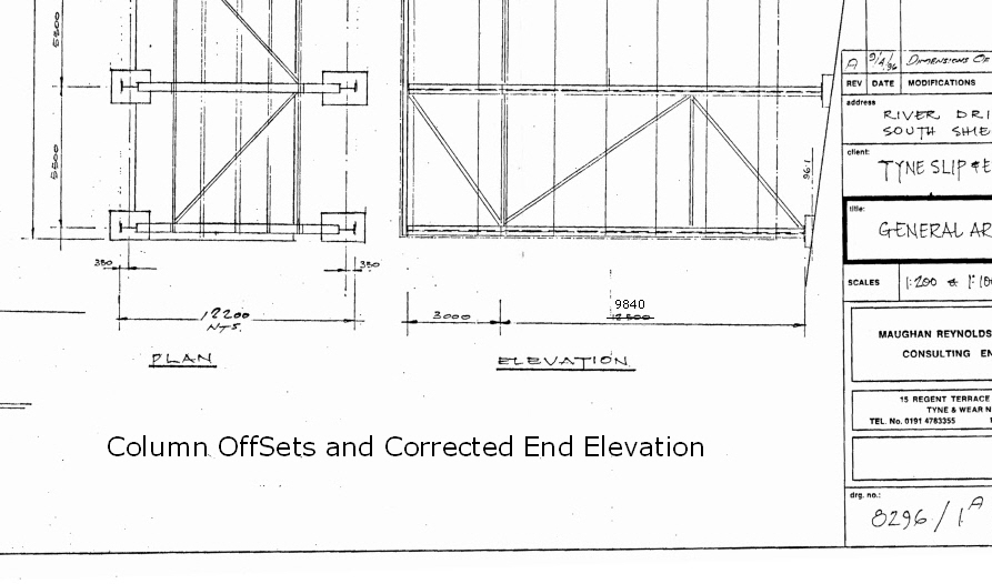 I have shown ‘Column Offsets etc. to illustrate that he is trying to make the case for lack of enforcement action with regards to width. To get to the dimension 12.9m one has to add two times 0.350m to 12.2m – a first class misrepresentation. This fabrication is in the same league as implying that the gable end in 8296/14 refers to the road end of the cover.
Faux Stage 2 Complaint: 2-Jun-2014.
We were at stage 2 by the 14 th January 2014:- If you are unable to supply me with answers to my questions could you please pass the issue to someone who can.
There are three things out of order in Mr Mansbridge’ urge to present the residents complaint to the Ombudsman with no reference to the variation in height:-
- the switch from complaint 248789 to 253539;
- at the end of the Planning Manager’s email, 28-Jan, he says “I can only suggest that if you do wish to pursue this matter further you ask that my Head of Service, George Mansbridge, responds to any remaining points you may have formally under stage 2 of the Council’s complaints procedure. You will have to write to him and say specifically what you remain unhappy about.” – the matter was not pursued because there was no requirement for it – the answer to why did he say that 8296/14 referred to the landward end was “I was wrong”.
- in Mr Mansbridge’ introduction he says “You have made it clear in your letter of 2nd May that you were not happy that I referred your email of 4th April 2014 on to my Planning Department – see response to Petition above.
There was some confusion because his initial response to my letter of the 4th April was to assign it to complaint 248789 which annoyed me, being unaware of its existence. I thought he was raising a new complaint and did not hesitate to complain about it. This might also explain the email from the Planning Manager later that month using 248789 for the first time. It appears he was covering himself for not responding to the letter that Mr Mansbridge had passed back to him.
This brings me to the main point of the letter, 2-May, about the conduct of Messrs Cunningham and Atkinson, which he totally ignored:
1. In an email from your Principle Planning Officer, Mr Cunningham, dated 13th Jan 2014:- “May I therefore suggest that you speak with the Chair of the residents group in respect of the points that you have raised below, as these have already been discussed and explained. If you are still not satisfied with the Council’s response then you should use the Council’s complaints procedure which has 3 stages.”
2. In an email from your Planning Manager, Mr Atkinson, dated 28th Jan 2014:- “I can only suggest that if you do wish to pursue this matter further you ask that my Head of Service, George Mansbridge, responds to any remaining points you may have formally under stage 2 of the Council’s complaints procedure. You will have to write to him and say specifically what you remain unhappy about.”
I finish by saying that if I had followed the suggestions by these officers there would have been no admission by the planning office that “the current structure is not built to approved plans.” One must bear in mind that:
1. Mr Cunningham said, “My understanding is that the responses that I had provided to you at this meeting enabled the matter to be closed.” He had told us at the meeting, later confirmed in writing, “I have explained during our meeting that the base and height of the structure are compliant…this is the end of the matter as far as I am concerned.”
2. in Mr Atkinson’s email of the 28th he was still pretending there was no variation in height by implying:
a) that 8296/1A was approved;
b) that the gable end on 8296/14 was that of the road end of the cover.
He cannot pass this letter back to planning, as he did with the 04-Aril one, because it concerns the conduct of his staff and all he says about the letter of 2-May is:
You have made it clear in your letter of 2nd May that you were not happy that I referred your email of 4th April 2014 on to my Planning Department. . . . . should you continue to be dissatisfied having exhausted the process and wish to refer the matter to the Local Government Ombudsman. For this reason I am treating this as a Stage 2 response.
This is a masterpiece in deception and effectively takes us back to January, pretending stage 1 of 248789 never happened and enabling him to repeat the misrepresentations by the planning office at that time:
- The height of the shelter does not significantly deviate from the approved scheme as you have suggested. The approved dimensions that I state are those which are annotated on drawing number 8296/1A
- 8296/14 – The engineer also chose to include a gable elevation of the structure on the same drawing but that was not drawn to scale.
He does say that if it would help he would be more than happy to meet with you to show you the relevant plans and elevation as this may clear up this specific point but he asks his secretary to raise a new complaint, 253939 which effectively closes 248789 down and hides:
- the repetition by 2 officers that the cover is compliant with condition 2;
- the wrongdoing in registering the original complaint;
- the admission/concession that the cover is 2.7m too high;
- that complaint 248789 has not been progressed after stage 1;
- that he has been reminded the shed is too high;
- a letter to him concerning the conduct of two of his planning staff has been ignored;
- that the Planning Manager only said the slope of the sides was not a material consideration, nothing about either the width or the height and hence either one of these deviations would normally require removal of the cover or a retrospective planning application to be sought.
The failure of the Council to bring 8296/14 to a meeting, 8-Jul, to discuss it should be noted. The meeting should have been called off once I was informed that Mr Atkinson was to attend. It was he, who said that drawing 8296/14 was not so scale and it was he who suggested that 8296/1A had been approved .
I did manage to say that the latter showed both ends of the cover to be the same height and this effectively bought the meeting to a close because there was no denying it. If the river end is 15.5m on 8296/1A then the road end is only 12.8m. We are back to “Which end is the true planned height?
In the email following the meeting, the planning Manager was still tying to plug the use of 8296/1A and to establish what he told us in January was reasonable by quoting Jonathan Wilson. The note about 8296/4 is not intended for benefit of anyone trying to decide which end’s dimension is correct. While it is authorised, it has no dimensions. I believe it is mentioned to divert attention from 8296/2 which is also authorised and has sufficient information to determine that the road end has a planned height of something like 13m
This does however bring us back to the first drawings submitted by UK Docks to the Council on 6-Sep-13 because Jonathan Wilson is the director of UK Docks Ltd whom I take to be responsible for handing over the unauthorised drawings with the intention to deceive. These are the same drawings sent by the Council to make their case to the Local Government Ombudsman.
MD 24-April-2017