UK Docks, River Drive Slipway Enclosure – Plans and Drawings
Condition 2 of the grant made in 1996 by the Tyne and Wear Development Corporation (T&WDC) states: “The development to which this permission relates shall be carried out in complete accordance with the approved plans and specifications.”
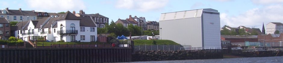
For over four months the Council kept on telling enquirers that the cover, enclosure or shed was built to approved plans. Examination of either of the two approved plans shows this not to be true.
It was apparent to the residents that the variation in planned height was same as the gradient, about 3m, but it was not until the drawing 8296/14 produced by Maughan Reynolds Partnership (the agents), to meet condition 4 that we were able to demonstrate, beyond doubt, that the enclosure was nearly 3m too tall. This drawing first appeared in the public domain in December 2013. The only drawing from 1996 held by the Council and authorised by the T&WDC shows a planned height of 12.7m at the inland end.
There is no dispute about the planned width. It is 12.2m and it was not till the end of January 2014 that the Council confirmed it was too wide at 13.1m. The footings were laid in 2001 and the width does not seem to have been measured till it was done by a resident in November 2013. This was made possible because the walls of the structure were now vertical and not sloping as planned.
Early correspondence with the Manager of the Planning office indicated that the change of gradient of the sides was not considered material i.e. the change in width and height were material differences.
The plans and drawings for the enclosure fall into two groups:
- ones that are not approved: these include the pair of drawings presented by UK Docks (longitudinal section and 8296/1B), the drawing held by South Tyneside Council since April 1996 (8296/1A) and a pre-planning sketch (ST269696);
- ones that are approved: 8296/2, and 8296/4 authorised by the T&WDC in 1996 and 8296/14 presented by the agents, Maughan Reynolds Partnership Ltd, and approved by the Planning Manager of South Tyneside Council in October 2013.
The following drawings have been left out because their inclusion is of no relevance and only serves to confuse matters:
-
8296/1A which like 1B shows a dimensional error at the landward gable end and bears no evidence of having been to the T&WDC and is not an approved drawing. The only difference between 1A and 1B being to the foundation detail;
-
8296/4 shows the layout of the translucent panels and is dimensionless;
- ST269696 which looks like a pre-planning sketch made by UK Docks.
Longitudinal Section and 8296/1B
Presented to the Council on September 6, 2013 by UK Docks. There is no evidence that these have even been seen, let alone authorised, by the T&WDC. 8296/1B which was an amendment to 8296/1A shows:
- it was drawn in February 1997 and it is doubtful if it is ‘legal’;
- the river end is shown as the same height as the landward end at 15.5m, therefore the roof should slope down towards the river with the same gradient as the slipway (2.7m). The roof is level in the longitudinal section so one of the dimensions is wrong.
The Council maintain that the landward end of either 1A or 1B is correct, giving a river end of 18.2m. Reference to authorised (1996) or approved (2013) drawings shows that the river end is correct giving a landward or road end of 12.8m.
The elevation shows the hip of the mansard at 3m below the top of the framework, about 1/4qr the way down, making the total height of the elevation about 12m. At the other end the hip is about 1/5th the way down giving a total height of 15m.
If that does not suit then one can use the gradient of 2.7m (96.1-93.4) to work out that the river end of the framework should be 15.5 not 18.5m as drawn. It has been stretched to match the other end.
This drawings are not authorised so the two arguments given to show that the likely planned height is about 12.8m are rather academic so it is probably safer to refer to approved or authorised drawings and either 8296/2 or 8296/14 will do.
8296/2
This is one of two drawings made in 1996 that have been authorised by the T&WDC as can be seen from the complete copy. This was retrieved from the Council’s archive in September 2013 but not made available for comment until the end of January 2014. This shows the details that are missing from the ‘longitudinal section’ sent into the Council by UK Docks:
- T&WDC authorisation stamp;
- drawing number, drawing date;
- the height of the roof top above the datum (118.8m);
- the height of the base above the datum (95.5m).
This give a height of 13.3m at the section and when adjustment is made for the landward end footings of 96.1m it gives a planned height of 12.7m.
8296/14
This drawing was produced as part of a submission to the Council by the agents, Maughan Reynolds Partnership, to meet condition 4. It was drawn in August 2013, received by the Council in September and approved by the Planning Manager on 14-Oct- 2013.
The additional notes show dimensions as 15.6m x 12.2m and these were originally made from an A4 copy. If the A1 drawing, which should be held by the Council is examined, one will see that the gable is drawn to a scale of 1:100 and is 16cm x 12.5cm. This shows a planned height of the river gable end of 16m and the Council’s legal section has said the drawing could never supersede the previously approved plans in terms of defining the dimensions of the approved development. Its publication in December 2013 should have finally put paid to the argument about which end of the enclosure had a planned height of 15.5m and it is not the landward end.
Misrepresentation
The Council have successfully maintained the myth that the planned height of the landward end is 15.5m by saying or suggesting that 8296/1A or 1B are approved and quoting a dimension that is specified incorrectly. They also ignore the fact that both drawings give the river end a planned height of 15.5m as well as the road end. They have failed to date, to provide any evidence i.e. an approved drawing, to back up what they say, that the planned height of the road end is 15.5m.
When the gable end on 8296/14 is mentioned the Council say things like it is not to scale or is just an engineer’s sketch which is misleading. They have also said that it refers to the road which is plainly wrong. They also said that on completion there is to be the opening on each of the gable ends. There is no longer a door on the landward end.
Misrepresentations such as those just outlined in these two paragraphs have enabled the Council to misinform the residents of Greens Place and Harbour View in the response to a Petition.
This strategy also enabled the Council to misinform the Local Government Ombudsman (LGO) so that the complaint about the variation on height was not upheld and they were then in a position to use the LGO’s decision to misinform other interested parties such as Members of Parliament.
It is worth noting that when they do quote the LGO they omit the last and most important part of the summary:
“The complainant says the shed is also 3 metres higher than it should be. The Council says it is not. There is no fault in how the Council decided the shed is the permitted height.”
The Council have not been able to provide any approved plans that will support this decision yet they say there is no evidence that the Local Government Ombudsman has been misinformed.