8296/1A
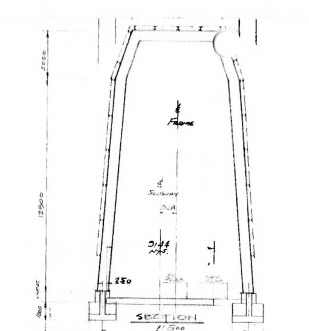
This drawing shows both ends of the enclosure as 15.5m, and as the roof does not have the same slope as the slipway, one of them must be wrong which is why it was not authorised.
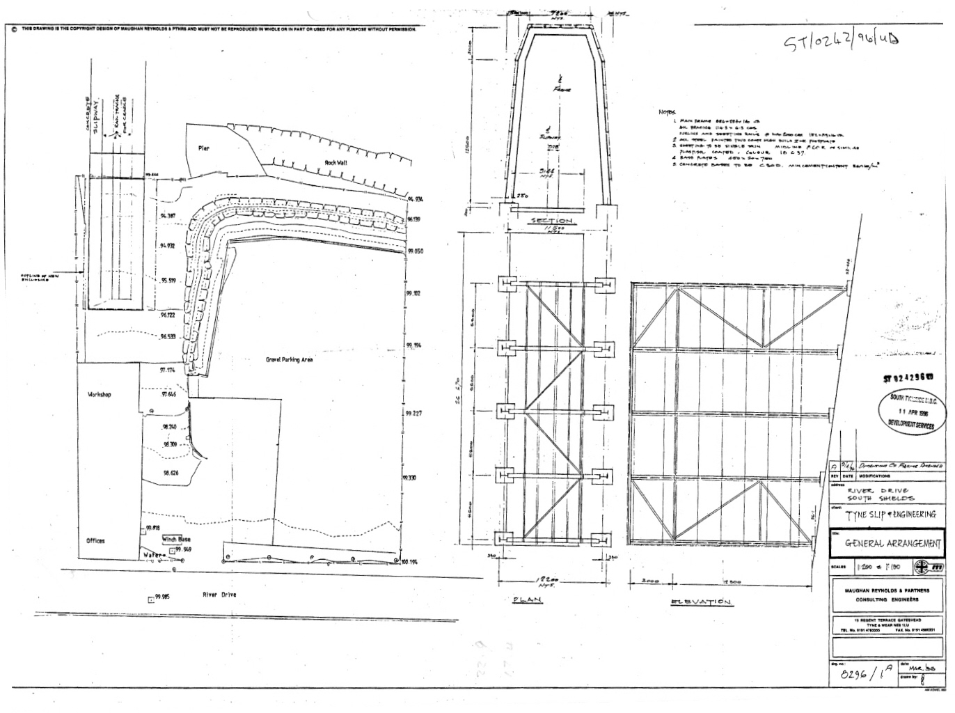
Both elevations, top centre and bottom left, show the hip of the mansard at 3m below the top, i.e. about 1/4qr the way down the landward end and a 1/5th down the river end, suggesting total height of the elevation of about 12m at the landward end and 15 meters at the river end.
This is a reasonable assessment of the heights of each end and it becomes clear that the height of the river end is correct at 15.5m and that makes the landward some 2.7m or the gradient less, 12.8m.
The Local Government Ombudsman says in #30 and #31 that:
30. Mr X (Mr Dawson) says the shed is also 3 metres higher than shown in the 1996 plans. He says a scale measurement from the plans shows a total height of 12.75 metres at one end of the shed.
31. “I have discussed this with a senior planning officer. The Council accepts that using a scale measurement against the 1996 drawings would not give a measurement of 15.5 metres. It says this plan has several drawings using different scales and some are foreshortened; possibly to fit on the paper. It says these are likely to be engineer’s drawings.
The senior planning officer was therefore repeating the lies told to the local residents, about the shed in 2013, to the Inspector for the Local Government Ombudsman.
It is irrelevant whether an engineer or an architect was responsible for the drawing. In this particular instance the drawing was not foreshortened, quite the opposite in fact. The side elevation was drawn to reflect the wrong height of 15.5m at the landward end. This is reflected in downhill or river end being nearly 7 times the gradient or 19m
With regard to the planned height the Senior Planning Officer was plainly wrong. However it is all academic as the drawing has not been approved. Reference to 8296/2, which is authorised, shows the landward end to have a planned height of 12.7m.
There is not a problem with the width and 8296/1A can be used to claim a planned width of 12.2m and the same is true of 8296/1B.
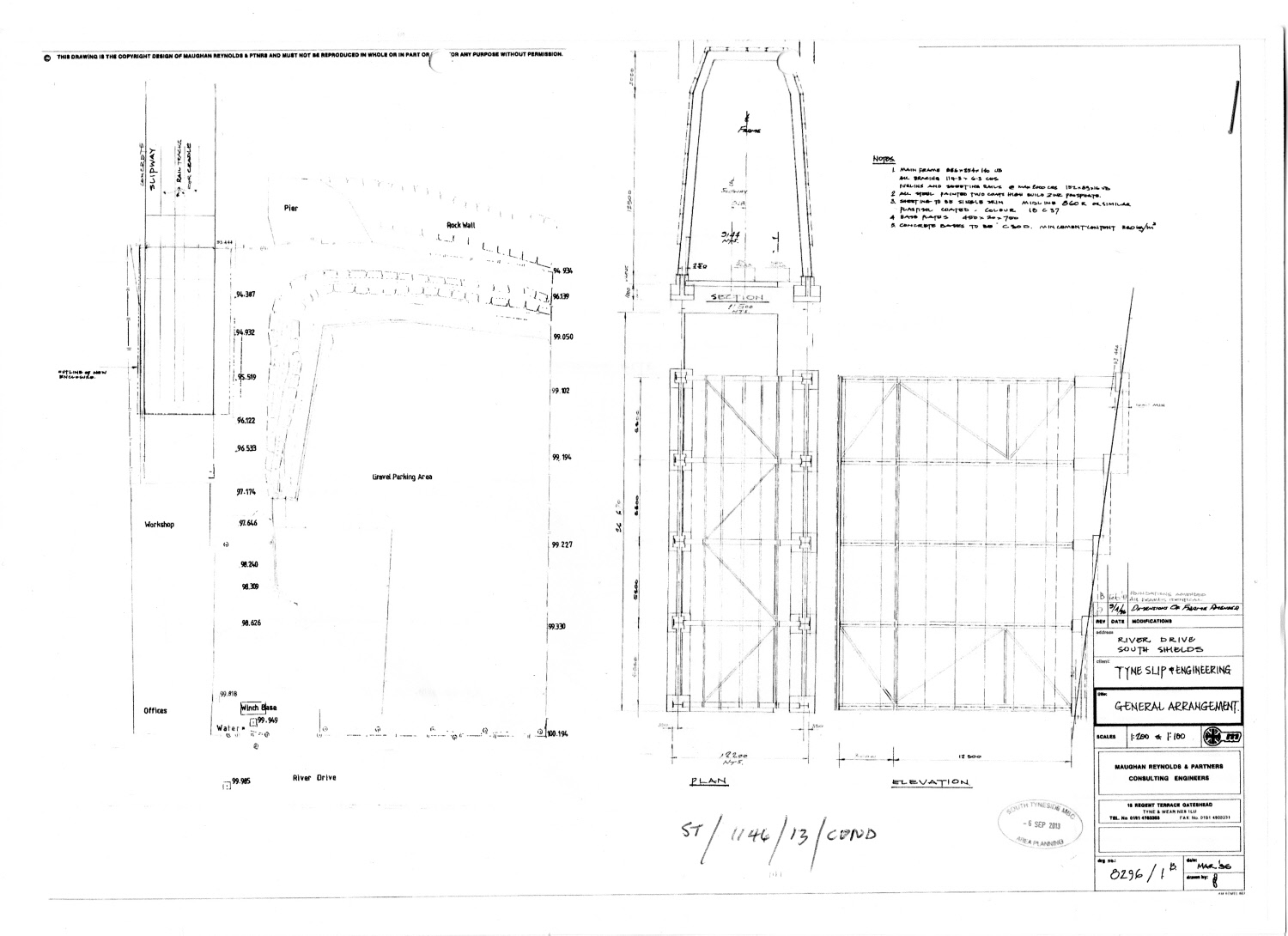
8296/1B
Example taken from 8296/2.
This was the second of two drawings in a pdf file, the first of which was a cropped copy of 8296/2 with the dimension showing the approved height of the shed removed: ST1AA3V00023_MFD-EZU14078-37788_3396_001.
The pair of drawings, received by the Council 06-Sep, 2013 provided by UK Docks and comprise a general site plan and a longitudinal section.
The pair were circulated by the Principal Planning Officer of South Tyneside Council in early September 2013 to hide the fact that shed would, when it was put into use, be taller and wider than the one for which they had been given permission.
The first thing to note about 1B is that it shows it was an amendment produced from 8296/1A made in February 97 and could not bear an authentication stamp of the Tyne and Wear Development Corporation.
Its use to show the approved height of the landward end of the shed is 15.5m therefore a fraudulent misrepresentation of the permitted height of the shed.
The Inspector for the Local Government Ombudsman says in #34 of her report that:-I have seen the 1996 plans. On plan 1/B the applicant has written the proposed elevations at the inland end as 12.5 metres plus 3 metres. Mr Dawson says the Council should not have taken the applicant’s word for this. The planning authority has to consider what an applicant applies for; it can grant or refuse this but it cannot make an applicant submit something different. This developer applied for a shed 15.5 metres high at the land end. The Tyne and Wear Development Corporation as planning authority approved this. The current Council had to accept this as the approved height.
The Tyne and Wear Development Corporation could not have approved 1/B in 1996 as it was an amendment made by the agent in February 1997. An amendment to 1A made in February 1997, not authorised, and probably not a legal document.
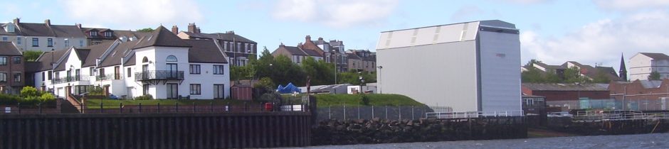
 Detail of the river end of the shed.
If the river end is 15.5m then the road end must be 12.8m.
The Council still maintain that 15.5m is the approved height and refused to admit they had made a mistake even after they were advised, with reference to the approved drawing, 8296/14, that approved height was 12.7m.
They were also reminded in an email to the Planning Manager in March 2014 by reference to 8296/2 which was authorised and shows a height of 12.7m and whoever sent the Ombudsman a copy of 8296/1B can justly be accused of fraudulent misrepresentation. It was one of a pair of drawing given to the Principal Planning Officer in September 2013 by UK Docks.